Search for Grid Square by Postcode
TQ11
Based in the South East English Region.
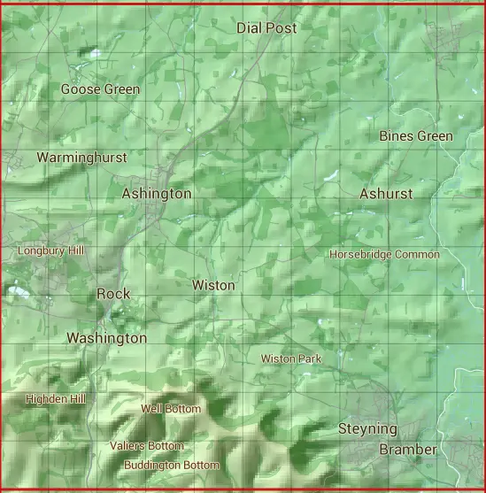
The TQ11 10 square kilometre grid intersects with the settlements of Abingworth,Ashington,Ashurst,Bramber,Castle Town,Dial Post,Goose Green,Henfield,Littleworth,Partridge Green,Rock,Shermanbury,Steyning,Storrington,Thakeham,Upper Beeding,Washington & Wiston.
TQ11
TQ11 is within the post towns of Henfield, Sussex, Horsham, Sussex, Pulborough, Sussex, Steyning, Sussex & Worthing, Sussex.
The square is within Arun District & Horsham District councils.
The TQ11 national grid square measures 10 km by 10 km and has an area of 1,000 kilometres squared.
The technical term for a 10 km map square is a Hectad.
When this 10 km square is divided into a grid 10 by 10 it gives the next size of grid square. This unit is called a Monad and measures 1km square. 100 monads fit in a 10km square.
Out of the monads generated from square TQ11, 1764 are land and -1664 are sea. Sea squares are disregarded on this site as they contain no land features.
|
|
|
|
|
|
 |
|
|
|
|
|
 |  |  |  |  |  |  |  |  |  |
 |  |  |  |  |  |  |  |  |  |
 |  |  |  |  |  |  |  |  |  |
 |  |  |  |  |  |  |  |  |  |
 |  |  |  |  |  |  |  |  |  |
 |  |  |  |  |  |  |  |  |  |
 |  |  |  |  |  |  |  |  |  |
 |  |  |  |  |  |  |  |  |  |
 |  |  |  |  |  |  |  |  |  |
 |  |  |  |  |  |  |  |  |  |
| Corner | Latitude | Longitude | Easting | Northing |
|---|---|---|---|---|
| South West Corner | 50.877041 | -0.437784 | 510000 | 110000 |
| South East Corner | 50.877041 | -0.292417 | 520000 | 110000 |
| North West Corner | 50.968919 | -0.437784 | 510000 | 120000 |
| North East Corner | 50.968919 | -0.292417 | 520000 | 120000 |