Search for Grid Square by Postcode
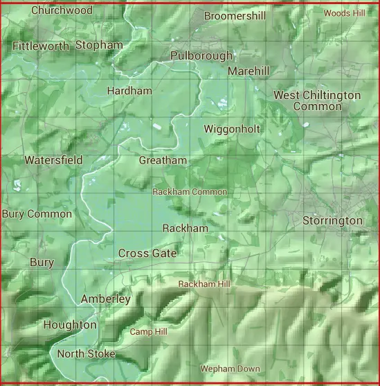
TQ01
Based in the South East English Region.
The TQ01 10 square kilometre grid intersects with the settlements of Abingworth,Amberley,Broomershill,Bury,Codmore Hill,Coldwaltham,Cootham,Cross Gate,Fittleworth,Houghton,Lower Horncroft,Marehill,Nutbourne,Pulborough,Rackham,Stopham,Storrington,Watersfield,West Chiltington & West Chiltington Common.
TQ01
TQ01 is within the post towns of Arundel, Sussex, Pulborough, Sussex & Worthing, Sussex.
The square is within Arun District, Chichester District & Horsham District councils.
The TQ01 national grid square measures 10 km by 10 km and has an area of 1,000 kilometres squared.
The technical term for a 10 km map square is a Hectad.
When this 10 km square is divided into a grid 10 by 10 it gives the next size of grid square. This unit is called a Monad and measures 1km square. 100 monads fit in a 10km square.
Out of the monads generated from square TQ01, 451 are land and -351 are sea. Sea squares are disregarded on this site as they contain no land features.
|
|
|
|
|
|
 |
|
|
|
|
|
 |  |  |  |  |  |  |  |  |  |
 |  |  |  |  |  |  |  |  |  |
 |  |  |  |  |  |  |  |  |  |
 |  |  |  |  |  |  |  |  |  |
 |  |  |  |  |  |  |  |  |  |
 |  |  |  |  |  |  |  |  |  |
 |  |  |  |  |  |  |  |  |  |
 |  |  |  |  |  |  |  |  |  |
 |  |  |  |  |  |  |  |  |  |
 |  |  |  |  |  |  |  |  |  |
| Corner | Latitude | Longitude | Easting | Northing |
|---|---|---|---|---|
| South West Corner | 50.879028 | -0.579879 | 500000 | 110000 |
| South East Corner | 50.879028 | -0.434770 | 510000 | 110000 |
| North West Corner | 50.970740 | -0.579879 | 500000 | 120000 |
| North East Corner | 50.970740 | -0.434770 | 510000 | 120000 |