Search for Grid Square by Postcode
TQ02
Based in the South East English Region.
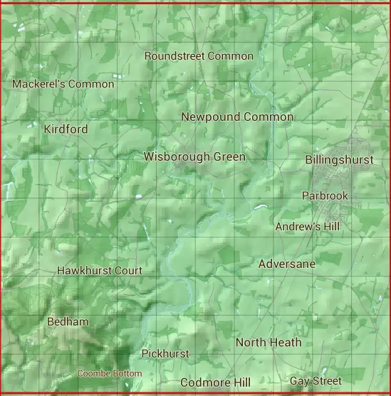
The TQ02 10 square kilometre grid intersects with the settlements of Adversane,Billingshurst,Codmore Hill,Five Oaks,Kirdford,Newpound Common,North Heath,Pickhurst & Wisborough Green.
TQ02
TQ02 is within the post towns of Billingshurst, Sussex, Petworth, Sussex & Pulborough, Sussex.
The square is within Chichester District & Horsham District councils.
The TQ02 national grid square measures 10 km by 10 km and has an area of 1,000 kilometres squared.
The technical term for a 10 km map square is a Hectad.
When this 10 km square is divided into a grid 10 by 10 it gives the next size of grid square. This unit is called a Monad and measures 1km square. 100 monads fit in a 10km square.
Out of the monads generated from square TQ02, 473 are land and -373 are sea. Sea squares are disregarded on this site as they contain no land features.
|
|
|
|
|
|
 |
|
|
|
|
|
 |  |  |  |  |  |  |  |  |  |
 |  |  |  |  |  |  |  |  |  |
 |  |  |  |  |  |  |  |  |  |
 |  |  |  |  |  |  |  |  |  |
 |  |  |  |  |  |  |  |  |  |
 |  |  |  |  |  |  |  |  |  |
 |  |  |  |  |  |  |  |  |  |
 |  |  |  |  |  |  |  |  |  |
 |  |  |  |  |  |  |  |  |  |
 |  |  |  |  |  |  |  |  |  |
| Corner | Latitude | Longitude | Easting | Northing |
|---|---|---|---|---|
| South West Corner | 50.968919 | -0.577139 | 500000 | 120000 |
| South East Corner | 50.968919 | -0.431741 | 510000 | 120000 |
| North West Corner | 51.060635 | -0.577139 | 500000 | 130000 |
| North East Corner | 51.060635 | -0.431741 | 510000 | 130000 |