Search for Grid Square by Postcode
NO50
Based in the Mid Scotland and Fife region of Scotland.
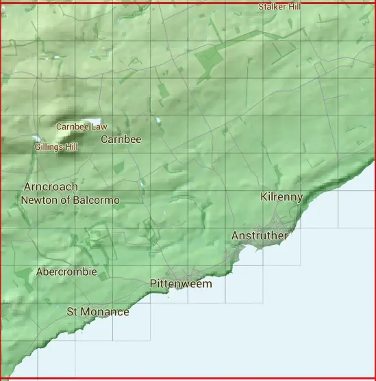
The NO50 10 square kilometre grid intersects with the settlements of Anstruther,Arncroach,Kilrenny,Pittenweem & St Monans.
NO50
NO50 is within the post towns of Anstruther, Fife, Leven, Fife & St. Andrews, Fife.
The square is within Fife council.
The NO50 national grid square measures 10 km by 10 km and has an area of 1,000 kilometres squared.
The technical term for a 10 km map square is a Hectad.
When this 10 km square is divided into a grid 10 by 10 it gives the next size of grid square. This unit is called a Monad and measures 1km square. 100 monads fit in a 10km square.
Out of the monads generated from square NO50, 362 are land and -262 are sea. Sea squares are disregarded on this site as they contain no land features.
|
|
|
|
|
|
 |
|
|
|
|
|
 |  |  |  |  |  |  |  |  |  |
 |  |  |  |  |  |  |  |  |  |
 |  |  |  |  |  |  |  |  |  |
 |  |  |  |  |  |  |  |  |  |
 |  |  |  |  |  |  |  |  |  |
 |  |  |  |  |  |  |  |  |  |
 |  |  |  |  |  |  |  | ||
 |  |  |  |  |  |  | |||
 |  |  |  | ||||||
 |  |
| Corner | Latitude | Longitude | Easting | Northing |
|---|---|---|---|---|
| South West Corner | 56.189976 | -2.809122 | 350000 | 700000 |
| South East Corner | 56.189976 | -2.646118 | 360000 | 700000 |
| North West Corner | 56.280759 | -2.809122 | 350000 | 710000 |
| North East Corner | 56.280759 | -2.646118 | 360000 | 710000 |