Search for Grid Square by Postcode
TQ07
Based in the London English Region & South East English Region.
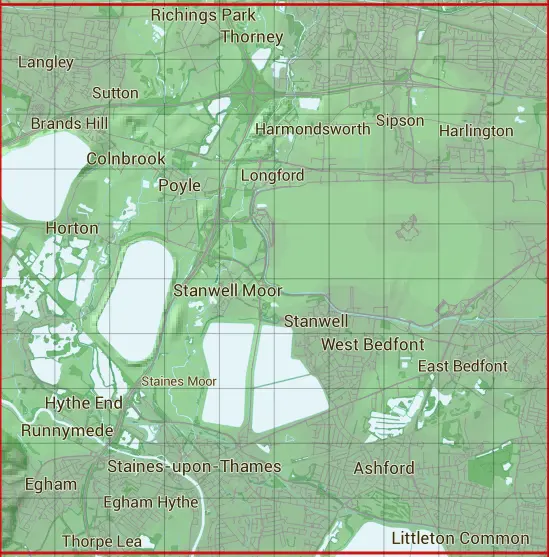
The TQ07 10 square kilometre grid intersects with the settlements of Ashford,Ashford Common,Colnbrook,Cranford,East Bedfont,Egham,Feltham,Hamondsworth,Harlington,Hayes Hillingdon,Heathrow Airport,Hillingdon,Horton,Hythe End,Laleham,Littleton Common,Longford,Poyle,Richings Park,Runnymede,Sipson,Slough,Staines-upon-Thames,Stanwell,Stanwell Moor,Stockley Park,Sunbury-on-Thames,Thorney,West Bedfont,West Drayton,Wraysbury & Yiewsley.
TQ07
TQ07 is within the post towns of Ashford, Middlesex, Egham, Surrey, Feltham, Middlesex, Hayes, Middlesex, Hounslow, Middlesex, Iver, Buckinghamshire, Slough, Buckinghamshire, Staines-upon-thames, Middlesex, Sunbury-on-thames, Middlesex, Uxbridge, Middlesex, West Drayton, Middlesex & Windsor, Berkshire.
The square is within Buckinghamshire, Hillingdon London Boro, Hounslow London Boro, Runnymede District, Slough, Spelthorne District & Windsor and Maidenhead councils.
The TQ07 national grid square measures 10 km by 10 km and has an area of 1,000 kilometres squared.
The technical term for a 10 km map square is a Hectad.
When this 10 km square is divided into a grid 10 by 10 it gives the next size of grid square. This unit is called a Monad and measures 1km square. 100 monads fit in a 10km square.
Out of the monads generated from square TQ07, 500 are land and -400 are sea. Sea squares are disregarded on this site as they contain no land features.
|
|
|
|
|
|
 |
|
|
|
|
|
 |  |  |  |  |  |  |  |  |  |
 |  |  |  |  |  |  |  |  |  |
 |  |  |  |  |  |  |  |  |  |
 |  |  |  |  |  |  |  |  |  |
 |  |  |  |  |  |  |  |  |  |
 |  |  |  |  |  |  |  |  |  |
 |  |  |  |  |  |  |  |  |  |
 |  |  |  |  |  |  |  |  |  |
 |  |  |  |  |  |  |  |  |  |
 |  |  |  |  |  |  |  |  |  |
| Corner | Latitude | Longitude | Easting | Northing |
|---|---|---|---|---|
| South West Corner | 51.418353 | -0.563232 | 500000 | 170000 |
| South East Corner | 51.418353 | -0.416365 | 510000 | 170000 |
| North West Corner | 51.510091 | -0.563232 | 500000 | 180000 |
| North East Corner | 51.510091 | -0.416365 | 510000 | 180000 |