Search for Grid Square by Postcode
TQ06
Based in the South East English Region.
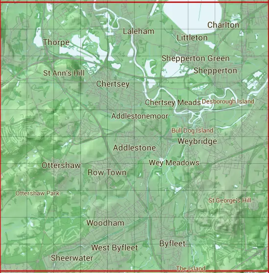
The TQ06 10 square kilometre grid intersects with the settlements of Addlestone,Brooklands,Burwood Park,Byfleet,Charlton,Chertsey,Cobham,Egham,Laleham,Littleton,Littleton Common,Lyne,New Haw,Ottershaw,Penton Hook,Pyrford,Row Town,Sheerwater,Shepperton,Shepperton Green,St George's Hill,Staines-upon-Thames,Stonehill,Stroude,Sunbury-on-Thames,Thorpe,Thorpe Green,Trumps Green,Upper Halliford,Virginia Water,Walton-on-Thames,West Byfleet,Weybridge,Whiteley Village,Woking & Woodham.
TQ06
TQ06 is within the post towns of Addlestone, Surrey, Ashford, Middlesex, Chertsey, Surrey, Cobham, Surrey, Egham, Surrey, Shepperton, Middlesex, Staines-upon-thames, Middlesex, Sunbury-on-thames, Middlesex, Virginia Water, Surrey, Walton-on-thames, Surrey, West Byfleet, Surrey, Weybridge, Surrey & Woking, Surrey.
The square is within Elmbridge District, Guildford District, Runnymede District, Spelthorne District, Surrey Heath District & Woking District councils.
The TQ06 national grid square measures 10 km by 10 km and has an area of 1,000 kilometres squared.
The technical term for a 10 km map square is a Hectad.
When this 10 km square is divided into a grid 10 by 10 it gives the next size of grid square. This unit is called a Monad and measures 1km square. 100 monads fit in a 10km square.
Out of the monads generated from square TQ06, 498 are land and -398 are sea. Sea squares are disregarded on this site as they contain no land features.
|
|
|
|
|
|
 |
|
|
|
|
|
 |  |  |  |  |  |  |  |  |  |
 |  |  |  |  |  |  |  |  |  |
 |  |  |  |  |  |  |  |  |  |
 |  |  |  |  |  |  |  |  |  |
 |  |  |  |  |  |  |  |  |  |
 |  |  |  |  |  |  |  |  |  |
 |  |  |  |  |  |  |  |  |  |
 |  |  |  |  |  |  |  |  |  |
 |  |  |  |  |  |  |  |  |  |
 |  |  |  |  |  |  |  |  |  |
| Corner | Latitude | Longitude | Easting | Northing |
|---|---|---|---|---|
| South West Corner | 51.328469 | -0.566043 | 500000 | 160000 |
| South East Corner | 51.328469 | -0.419472 | 510000 | 160000 |
| North West Corner | 51.420203 | -0.566043 | 500000 | 170000 |
| North East Corner | 51.420203 | -0.419472 | 510000 | 170000 |