Search for Grid Square by Postcode
SS81
Based in the South West English Region.
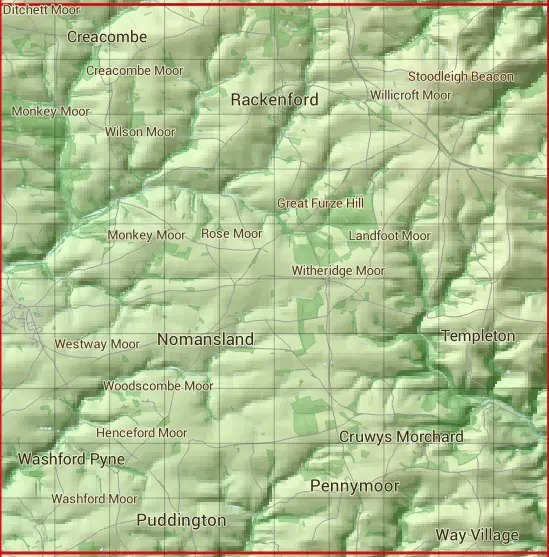
The SS81 10 square kilometre grid intersects with the settlements of Nomansland,Pennymoor,Puddington,Rackenford & Witheridge.
SS81
SS81 is within the post towns of Crediton, Devon, South Molton, Devon & Tiverton, Devon.
The square is within Mid Devon District & North Devon District councils.
The SS81 national grid square measures 10 km by 10 km and has an area of 1,000 kilometres squared.
The technical term for a 10 km map square is a Hectad.
When this 10 km square is divided into a grid 10 by 10 it gives the next size of grid square. This unit is called a Monad and measures 1km square. 100 monads fit in a 10km square.
Out of the monads generated from square SS81, 337 are land and -237 are sea. Sea squares are disregarded on this site as they contain no land features.
|
|
|
|
|
|
 |
|
|
|
|
|
 |  |  |  |  |  |  |  |  |  |
 |  |  |  |  |  |  |  |  |  |
 |  |  |  |  |  |  |  |  |  |
 |  |  |  |  |  |  |  |  |  |
 |  |  |  |  |  |  |  |  |  |
 |  |  |  |  |  |  |  |  |  |
 |  |  |  |  |  |  |  |  |  |
 |  |  |  |  |  |  |  |  |  |
 |  |  |  |  |  |  |  |  |  |
 |  |  |  |  |  |  |  |  |  |
| Corner | Latitude | Longitude | Easting | Northing |
|---|---|---|---|---|
| South West Corner | 50.876992 | -3.710320 | 280000 | 110000 |
| South East Corner | 50.876992 | -3.564947 | 290000 | 110000 |
| North West Corner | 50.968875 | -3.710320 | 280000 | 120000 |
| North East Corner | 50.968875 | -3.564947 | 290000 | 120000 |