Search for Grid Square by Postcode
SU17
Based in the South West English Region.
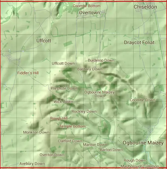
The SU17 10 square kilometre grid intersects with the settlements of Avebury,Berwick Bassett,Broad Hinton,Chiseldon,Draycot Foliat,Marlborough,Ogbourne Maizey,Ogbourne St Andrew,Ogbourne St George,Winterbourne Bassett & Wroughton.
SU17
SU17 is within the post towns of Marlborough, Wiltshire & Swindon, Wiltshire.
The square is within Swindon & Wiltshire councils.
The SU17 national grid square measures 10 km by 10 km and has an area of 1,000 kilometres squared.
The technical term for a 10 km map square is a Hectad.
When this 10 km square is divided into a grid 10 by 10 it gives the next size of grid square. This unit is called a Monad and measures 1km square. 100 monads fit in a 10km square.
Out of the monads generated from square SU17, 525 are land and -425 are sea. Sea squares are disregarded on this site as they contain no land features.
|
|
|
|
|
|
 |
|
|
|
|
|
 |  |  |  |  |  |  |  |  |  |
 |  |  |  |  |  |  |  |  |  |
 |  |  |  |  |  |  |  |  |  |
 |  |  |  |  |  |  |  |  |  |
 |  |  |  |  |  |  |  |  |  |
 |  |  |  |  |  |  |  |  |  |
 |  |  |  |  |  |  |  |  |  |
 |  |  |  |  |  |  |  |  |  |
 |  |  |  |  |  |  |  |  |  |
 |  |  |  |  |  |  |  |  |  |
| Corner | Latitude | Longitude | Easting | Northing |
|---|---|---|---|---|
| South West Corner | 51.428655 | -1.857542 | 410000 | 170000 |
| South East Corner | 51.428655 | -1.713141 | 420000 | 170000 |
| North West Corner | 51.518834 | -1.857542 | 410000 | 180000 |
| North East Corner | 51.518834 | -1.713141 | 420000 | 180000 |