Search for Grid Square by Postcode
SP50
Based in the South East English Region.
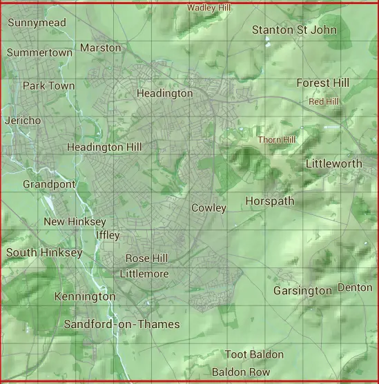
The SP50 10 square kilometre grid intersects with the settlements of Bayworth,Boars Hill,Cuddesdon,Denton,Elsfield,Forest Hill,Garsington,Holton,Horspath,Kennington,Littleworth,Oxford,Sandford-on-Thames,South Hinksey,Stanton St John & Wheatley.
SP50
SP50 is within the post towns of Abingdon, Berkshire & Oxford, Oxfordshire.
The square is within Oxford District, South Oxfordshire District & Vale of White Horse District councils.
The SP50 national grid square measures 10 km by 10 km and has an area of 1,000 kilometres squared.
The technical term for a 10 km map square is a Hectad.
When this 10 km square is divided into a grid 10 by 10 it gives the next size of grid square. This unit is called a Monad and measures 1km square. 100 monads fit in a 10km square.
Out of the monads generated from square SP50, 523 are land and -423 are sea. Sea squares are disregarded on this site as they contain no land features.
|
|
|
|
|
|
 |
|
|
|
|
|
 |  |  |  |  |  |  |  |  |  |
 |  |  |  |  |  |  |  |  |  |
 |  |  |  |  |  |  |  |  |  |
 |  |  |  |  |  |  |  |  |  |
 |  |  |  |  |  |  |  |  |  |
 |  |  |  |  |  |  |  |  |  |
 |  |  |  |  |  |  |  |  |  |
 |  |  |  |  |  |  |  |  |  |
 |  |  |  |  |  |  |  |  |  |
 |  |  |  |  |  |  |  |  |  |
| Corner | Latitude | Longitude | Easting | Northing |
|---|---|---|---|---|
| South West Corner | 51.695555 | -1.277954 | 450000 | 200000 |
| South East Corner | 51.695555 | -1.131561 | 460000 | 200000 |
| North West Corner | 51.786438 | -1.277954 | 450000 | 210000 |
| North East Corner | 51.786438 | -1.131561 | 460000 | 210000 |