Search for Grid Square by Postcode
SP61
Based in the South East English Region.
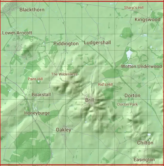
The SP61 10 square kilometre grid intersects with the settlements of Ambrosden,Blackthorn,Brill,Chilton,Dorton,Easington,Horton-cum-Studley,Kingswood,Lower Arncott,Ludgershall,Oakley,Piddington & Upper Arncott.
SP61
SP61 is within the post towns of Aylesbury, Buckinghamshire, Bicester, Oxfordshire, Kidlington, Oxfordshire & Oxford, Oxfordshire.
The square is within Buckinghamshire, Cherwell District & South Oxfordshire District councils.
The SP61 national grid square measures 10 km by 10 km and has an area of 1,000 kilometres squared.
The technical term for a 10 km map square is a Hectad.
When this 10 km square is divided into a grid 10 by 10 it gives the next size of grid square. This unit is called a Monad and measures 1km square. 100 monads fit in a 10km square.
Out of the monads generated from square SP61, 523 are land and -423 are sea. Sea squares are disregarded on this site as they contain no land features.
|
|
|
|
|
|
 |
|
|
|
|
|
 |  |  |  |  |  |  |  |  |  |
 |  |  |  |  |  |  |  |  |  |
 |  |  |  |  |  |  |  |  |  |
 |  |  |  |  |  |  |  |  |  |
 |  |  |  |  |  |  |  |  |  |
 |  |  |  |  |  |  |  |  |  |
 |  |  |  |  |  |  |  |  |  |
 |  |  |  |  |  |  |  |  |  |
 |  |  |  |  |  |  |  |  |  |
 |  |  |  |  |  |  |  |  |  |
| Corner | Latitude | Longitude | Easting | Northing |
|---|---|---|---|---|
| South West Corner | 51.784298 | -1.131561 | 460000 | 210000 |
| South East Corner | 51.784298 | -0.984594 | 470000 | 210000 |
| North West Corner | 51.875358 | -1.131561 | 460000 | 220000 |
| North East Corner | 51.875358 | -0.984594 | 470000 | 220000 |