Search for Grid Square by Postcode
ST20
Based in the South West English Region.
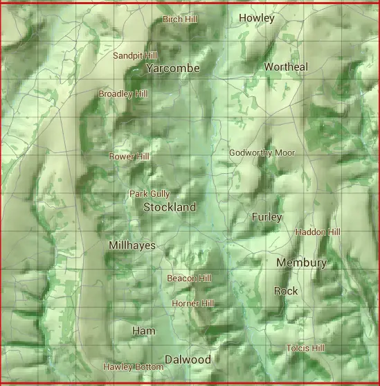
The ST20 10 square kilometre grid intersects with the settlements of Cotleigh,Dalwood,Furley,Membury,Millhayes,Rawridge,Smallridge,Stockland,Upottery,Wambrook,Wilmington & Yarcombe.
ST20
ST20 is within the post towns of Axminster, Devon, Chard, Somerset & Honiton, Devon.
The square is within East Devon District & South Somerset District councils.
The ST20 national grid square measures 10 km by 10 km and has an area of 1,000 kilometres squared.
The technical term for a 10 km map square is a Hectad.
When this 10 km square is divided into a grid 10 by 10 it gives the next size of grid square. This unit is called a Monad and measures 1km square. 100 monads fit in a 10km square.
Out of the monads generated from square ST20, 497 are land and -397 are sea. Sea squares are disregarded on this site as they contain no land features.
|
|
|
|
|
|
 |
|
|
|
|
|
 |  |  |  |  |  |  |  |  |  |
 |  |  |  |  |  |  |  |  |  |
 |  |  |  |  |  |  |  |  |  |
 |  |  |  |  |  |  |  |  |  |
 |  |  |  |  |  |  |  |  |  |
 |  |  |  |  |  |  |  |  |  |
 |  |  |  |  |  |  |  |  |  |
 |  |  |  |  |  |  |  |  |  |
 |  |  |  |  |  |  |  |  |  |
 |  |  |  |  |  |  |  |  |  |
| Corner | Latitude | Longitude | Easting | Northing |
|---|---|---|---|---|
| South West Corner | 50.794013 | -3.138621 | 320000 | 100000 |
| South East Corner | 50.794013 | -2.994574 | 330000 | 100000 |
| North West Corner | 50.885221 | -3.138621 | 320000 | 110000 |
| North East Corner | 50.885221 | -2.994574 | 330000 | 110000 |