Search for Grid Square by Postcode
ST11
Based in the South West English Region.
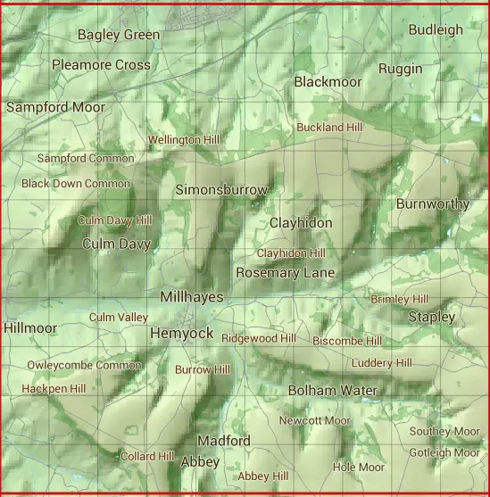
The ST11 10 square kilometre grid intersects with the settlements of Bagley Green,Burnworthy,Culmstock,Garlandhayes,Hemyock,Millhayes,Pleamore Cross,Rockwell Green,Sampford Arundel,Smeatharpe & Wellington.
ST11
ST11 is within the post towns of Cullompton, Devon, Honiton, Devon, Taunton, Somerset & Wellington, Somerset.
The square is within East Devon District, Mid Devon District & Somerset West and Taunton District councils.
The ST11 national grid square measures 10 km by 10 km and has an area of 1,000 kilometres squared.
The technical term for a 10 km map square is a Hectad.
When this 10 km square is divided into a grid 10 by 10 it gives the next size of grid square. This unit is called a Monad and measures 1km square. 100 monads fit in a 10km square.
Out of the monads generated from square ST11, 1817 are land and -1717 are sea. Sea squares are disregarded on this site as they contain no land features.
|
|
|
|
|
|
 |
|
|
|
|
|
 |  |  |  |  |  |  |  |  |  |
 |  |  |  |  |  |  |  |  |  |
 |  |  |  |  |  |  |  |  |  |
 |  |  |  |  |  |  |  |  |  |
 |  |  |  |  |  |  |  |  |  |
 |  |  |  |  |  |  |  |  |  |
 |  |  |  |  |  |  |  |  |  |
 |  |  |  |  |  |  |  |  |  |
 |  |  |  |  |  |  |  |  |  |
 |  |  |  |  |  |  |  |  |  |
| Corner | Latitude | Longitude | Easting | Northing |
|---|---|---|---|---|
| South West Corner | 50.882449 | -3.283215 | 310000 | 110000 |
| South East Corner | 50.882449 | -3.138621 | 320000 | 110000 |
| North West Corner | 50.973829 | -3.283215 | 310000 | 120000 |
| North East Corner | 50.973829 | -3.138621 | 320000 | 120000 |