Search for Grid Square by Postcode
ST17
Based in the South Wales Central region of Scotland.
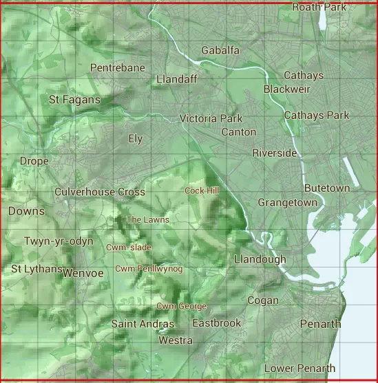
The ST17 10 square kilometre grid intersects with the settlements of Barry,Cardiff,Dinas Powys,Downs,Leckwith,Michaelston-le-Pit / Llanfihangel-y-pwll,Penarth,Rhydlafr,St Fagans,Twyn-yr-odyn & Wenvoe.
ST17
ST17 is within the post towns of Barry, Glamorgan, Cardiff, Glamorgan, Dinas Powys, Glamorgan & Penarth, Glamorgan.
The square is within Bro Morgannwg - the Vale of Glamorgan & Caerdydd - Cardiff councils.
The ST17 national grid square measures 10 km by 10 km and has an area of 1,000 kilometres squared.
The technical term for a 10 km map square is a Hectad.
When this 10 km square is divided into a grid 10 by 10 it gives the next size of grid square. This unit is called a Monad and measures 1km square. 100 monads fit in a 10km square.
Out of the monads generated from square ST17, 460 are land and -360 are sea. Sea squares are disregarded on this site as they contain no land features.
|
|
|
|
|
|
 |
|
|
|
|
|
 |  |  |  |  |  |  |  |  |  |
 |  |  |  |  |  |  |  |  |  |
 |  |  |  |  |  |  |  |  |  |
 |  |  |  |  |  |  |  |  |  |
 |  |  |  |  |  |  |  |  |  |
 |  |  |  |  |  |  |  |  |  |
 |  |  |  |  |  |  |  |  |  |
 |  |  |  |  |  |  |  |  |  |
 |  |  |  |  |  |  |  |  |  |
 |  |  |  |  |  |  |  |  |  |
| Corner | Latitude | Longitude | Easting | Northing |
|---|---|---|---|---|
| South West Corner | 51.421840 | -3.298314 | 310000 | 170000 |
| South East Corner | 51.421840 | -3.151978 | 320000 | 170000 |
| North West Corner | 51.513240 | -3.298314 | 310000 | 180000 |
| North East Corner | 51.513240 | -3.151978 | 320000 | 180000 |