Search for Grid Square by Postcode
NZ30
Based in the North East English Region & Yorkshire and the Humber English Region.
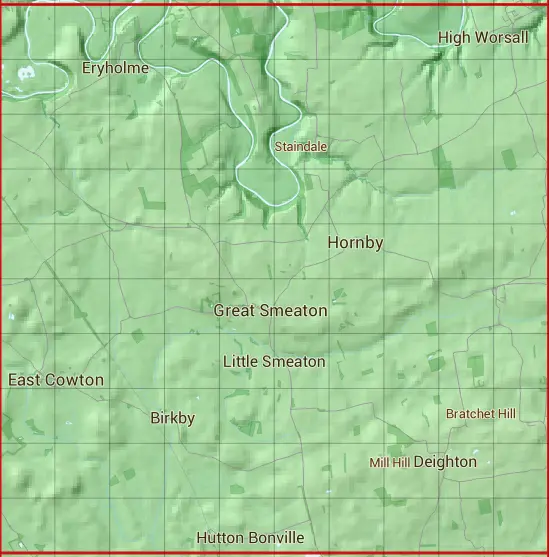
The NZ30 10 square kilometre grid intersects with the settlements of Appleton Wiske,Birkby,Deighton,East Cowton,Great Smeaton,Hornby,Hurworth-on-Tees,Low Worsall & Welbury.
NZ30
NZ30 is within the post towns of Darlington, County Durham, Northallerton, Yorkshire, Stockton-on-tees, County Durham & Yarm, Yorkshire.
The square is within Darlington, Hambleton District, Richmondshire District & Stockton-on-Tees councils.
The NZ30 national grid square measures 10 km by 10 km and has an area of 1,000 kilometres squared.
The technical term for a 10 km map square is a Hectad.
When this 10 km square is divided into a grid 10 by 10 it gives the next size of grid square. This unit is called a Monad and measures 1km square. 100 monads fit in a 10km square.
Out of the monads generated from square NZ30, 418 are land and -318 are sea. Sea squares are disregarded on this site as they contain no land features.
|
|
|
|
|
|
 |
|
|
|
|
|
 |  |  |  |  |  |  |  |  |  |
 |  |  |  |  |  |  |  |  |  |
 |  |  |  |  |  |  |  |  |  |
 |  |  |  |  |  |  |  |  |  |
 |  |  |  |  |  |  |  |  |  |
 |  |  |  |  |  |  |  |  |  |
 |  |  |  |  |  |  |  |  |  |
 |  |  |  |  |  |  |  |  |  |
 |  |  |  |  |  |  |  |  |  |
 |  |  |  |  |  |  |  |  |  |
| Corner | Latitude | Longitude | Easting | Northing |
|---|---|---|---|---|
| South West Corner | 54.393924 | -1.539478 | 430000 | 500000 |
| South East Corner | 54.393924 | -1.384130 | 440000 | 500000 |
| North West Corner | 54.484476 | -1.539478 | 430000 | 510000 |
| North East Corner | 54.484476 | -1.384130 | 440000 | 510000 |