Search for Grid Square by Postcode
NH22
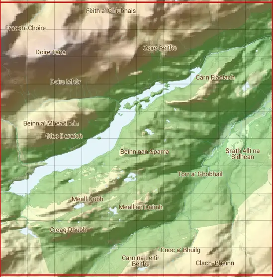
Based in the Highlands and Islands region of Scotland.
The NH22 10 square kilometre grid intersects with the settlement of Tomich.
NH22
NH22 is within the post town of Beauly, Inverness-shire.
The square is within Highland council.
The NH22 national grid square measures 10 km by 10 km and has an area of 1,000 kilometres squared.
The technical term for a 10 km map square is a Hectad.
When this 10 km square is divided into a grid 10 by 10 it gives the next size of grid square. This unit is called a Monad and measures 1km square. 100 monads fit in a 10km square.
Out of the monads generated from square NH22, 1842 are land and -1742 are sea. Sea squares are disregarded on this site as they contain no land features.
|
|
|
|
|
|
 |
|
|
|
|
|
 |  |  |  |  |  |  |  |  |  |
 |  |  |  |  |  |  |  |  |  |
 |  |  |  |  |  |  |  |  |  |
 |  |  |  |  |  |  |  |  |  |
 |  |  |  |  |  |  |  |  |  |
 |  |  |  |  |  |  |  |  |  |
 |  |  |  |  |  |  |  |  |  |
 |  |  |  |  |  |  |  |  |  |
 |  |  |  |  |  |  |  |  |  |
 |  |  |  |  |  |  |  |  |  |
| Corner | Latitude | Longitude | Easting | Northing |
|---|---|---|---|---|
| South West Corner | 57.235189 | -4.991282 | 220000 | 820000 |
| South East Corner | 57.235189 | -4.818556 | 230000 | 820000 |
| North West Corner | 57.328732 | -4.991282 | 220000 | 830000 |
| North East Corner | 57.328732 | -4.818556 | 230000 | 830000 |
1 KM Squares within the NH22 10 KM Square
NH2020 NH2021 NH2022 NH2023 NH2024 NH2025 NH2026 NH2027 NH2028 NH2029 NH2120 NH2121 NH2122 NH2123 NH2124 NH2125 NH2126 NH2127 NH2128 NH2129 NH2220 NH2221 NH2222 NH2223 NH2224 NH2225 NH2226 NH2227 NH2228 NH2229 NH2320 NH2321 NH2322
NH2323 NH2324 NH2325 NH2326 NH2327 NH2328 NH2329 NH2420 NH2421 NH2422 NH2423 NH2424 NH2425 NH2426 NH2427 NH2428 NH2429 NH2520 NH2521 NH2522 NH2523 NH2524 NH2525 NH2526 NH2527 NH2528 NH2529 NH2620 NH2621 NH2622 NH2623 NH2624 NH2625