Search for Grid Square by Postcode
NH21
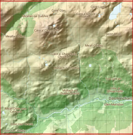
Based in the Highlands and Islands region of Scotland.
NH21
NH21 is within the post towns of Beauly, Inverness-shire & Inverness, Inverness-shire.
The square is within Highland council.
The NH21 national grid square measures 10 km by 10 km and has an area of 1,000 kilometres squared.
The technical term for a 10 km map square is a Hectad.
When this 10 km square is divided into a grid 10 by 10 it gives the next size of grid square. This unit is called a Monad and measures 1km square. 100 monads fit in a 10km square.
Out of the monads generated from square NH21, 516 are land and -416 are sea. Sea squares are disregarded on this site as they contain no land features.
|
|
|
|
|
|
 |
|
|
|
|
|
 |  |  |  |  |  |  |  |  |  |
 |  |  |  |  |  |  |  |  |  |
 |  |  |  |  |  |  |  |  |  |
 |  |  |  |  |  |  |  |  |  |
 |  |  |  |  |  |  |  |  |  |
 |  |  |  |  |  |  |  |  |  |
 |  |  |  |  |  |  |  |  |  |
 |  |  |  |  |  |  |  |  |  |
 |  |  |  |  |  |  |  |  |  |
 |  |  |  |  |  |  |  |  |  |
| Corner | Latitude | Longitude | Easting | Northing |
|---|---|---|---|---|
| South West Corner | 57.145482 | -4.984007 | 220000 | 810000 |
| South East Corner | 57.145482 | -4.811723 | 230000 | 810000 |
| North West Corner | 57.239013 | -4.984007 | 220000 | 820000 |
| North East Corner | 57.239013 | -4.811723 | 230000 | 820000 |
1 KM Squares within the NH21 10 KM Square
NH2010 NH2011 NH2012 NH2013 NH2014 NH2015 NH2016 NH2017 NH2018 NH2019 NH2110 NH2111 NH2112 NH2113 NH2114 NH2115 NH2116 NH2117 NH2118 NH2119 NH2210 NH2211 NH2212 NH2213 NH2214 NH2215 NH2216 NH2217 NH2218 NH2219 NH2310 NH2311 NH2312
NH2313 NH2314 NH2315 NH2316 NH2317 NH2318 NH2319 NH2410 NH2411 NH2412 NH2413 NH2414 NH2415 NH2416 NH2417 NH2418 NH2419 NH2510 NH2511 NH2512 NH2513 NH2514 NH2515 NH2516 NH2517 NH2518 NH2519 NH2610 NH2611 NH2612 NH2613 NH2614 NH2615