Search for Grid Square by Postcode
TQ97
Based in the South East English Region.
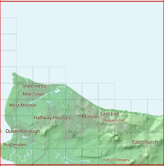
The TQ97 10 square kilometre grid intersects with the settlements of Eastchurch,Halfway Houses,Minster,Queenborough & Sheerness.
TQ97
TQ97 is within the post towns of Queenborough, Kent, Rochester, Kent, Sheerness, Kent & Sittingbourne, Kent.
The square is within Medway & Swale District councils.
The TQ97 national grid square measures 10 km by 10 km and has an area of 1,000 kilometres squared.
The technical term for a 10 km map square is a Hectad.
When this 10 km square is divided into a grid 10 by 10 it gives the next size of grid square. This unit is called a Monad and measures 1km square. 100 monads fit in a 10km square.
Out of the monads generated from square TQ97, 463 are land and -363 are sea. Sea squares are disregarded on this site as they contain no land features.
|
|
|
|
|
|
 |
|
|
|
|
|
 | |||||||||
 | |||||||||
 | |||||||||
 |  |  |  | ||||||
 |  |  |  |  |  |  | |||
 |  |  |  |  |  |  |  |  |  |
 |  |  |  |  |  |  |  |  |  |
 |  |  |  |  |  |  |  |  |  |
 |  |  |  |  |  |  |  |  |  |
| Corner | Latitude | Longitude | Easting | Northing |
|---|---|---|---|---|
| South West Corner | 51.393781 | 0.729899 | 590000 | 170000 |
| South East Corner | 51.393781 | 0.879105 | 600000 | 170000 |
| North West Corner | 51.487028 | 0.729899 | 590000 | 180000 |
| North East Corner | 51.487028 | 0.879105 | 600000 | 180000 |