Search for Grid Square by Postcode
TQ32
Based in the South East English Region.
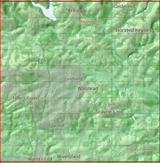
The TQ32 10 square kilometre grid intersects with the settlements of Abbotsford,Ardingly,Balcombe,Brook Street,Burgess Hill,Cinder Hill,Cuckfield,Haywards Heath,Horsted Keynes,North Chailey,Scayne's Hill,Wivelsfield & Wivelsfield Green.
TQ32
TQ32 is within the post towns of Burgess Hill, Sussex, Haywards Heath, Sussex, Lewes, Sussex & Uckfield, Sussex.
The square is within Lewes District, Mid Sussex District & Wealden District councils.
The TQ32 national grid square measures 10 km by 10 km and has an area of 1,000 kilometres squared.
The technical term for a 10 km map square is a Hectad.
When this 10 km square is divided into a grid 10 by 10 it gives the next size of grid square. This unit is called a Monad and measures 1km square. 100 monads fit in a 10km square.
Out of the monads generated from square TQ32, 515 are land and -415 are sea. Sea squares are disregarded on this site as they contain no land features.
|
|
|
|
|
|
 |
|
|
|
|
|
 |  |  |  |  |  |  |  |  |  |
 |  |  |  |  |  |  |  |  |  |
 |  |  |  |  |  |  |  |  |  |
 |  |  |  |  |  |  |  |  |  |
 |  |  |  |  |  |  |  |  |  |
 |  |  |  |  |  |  |  |  |  |
 |  |  |  |  |  |  |  |  |  |
 |  |  |  |  |  |  |  |  |  |
 |  |  |  |  |  |  |  |  |  |
 |  |  |  |  |  |  |  |  |  |
| Corner | Latitude | Longitude | Easting | Northing |
|---|---|---|---|---|
| South West Corner | 50.962418 | -0.150082 | 530000 | 120000 |
| South East Corner | 50.962418 | -0.003912 | 540000 | 120000 |
| North West Corner | 51.054635 | -0.150082 | 530000 | 130000 |
| North East Corner | 51.054635 | -0.003912 | 540000 | 130000 |