Search for Grid Square by Postcode
TQ27
Based in the London English Region.
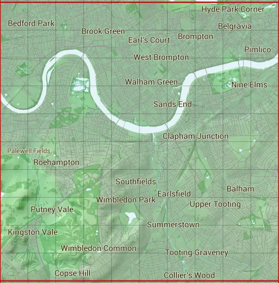
The TQ27 10 square kilometre grid intersects with the settlements of Acton,Balham,Barnes,Battersea,Bedford Park,Belgravia,Brentford,Brompton,Chelsea,Chelsea Harbour,Chiswick,Clapham,Clapham Common,Clapham Junction,Clapham Park,Colliers Wood,Coombe,Copse Hill,Earl's Court,Earlsfield,East Sheen,Fulham,Furzedown,Gunersbury,Hammersmith,Kensington,Kew,Kingston Vale,Knightsbridge,Mayfair,Merton,Mitcham,Mortlake,New Malden,Nine Elms,Notting Hill,Pimlico,Putney,Putney Heath,Putney Vale,Roehampton,Sands End,Shepherds Bush,Sourhfields,South Lambeth,St James,Stamford Brook,Streatham,Streatham Hill,Streatham Park,Summerstown,Tooting,Turnham Green,Upper Tooting,Victoria,Walham Green,Wandsworth,Wandsworth Common,West Brompton,West Hill,Westminster,White City,Whitehall & Wimbledon.
TQ27
TQ27 is within the post towns of Kingston Upon Thames, Surrey, London, Middlesex, London, Surrey, Mitcham, Surrey, New Malden, Surrey & Richmond, Surrey.
The square is within City of Westminster London Boro, Ealing London Boro, Hammersmith and Fulham London Boro, Hounslow London Boro, Kensington and Chelsea London Boro, Kingston upon Thames London Boro, Lambeth London Boro, Merton London Boro, Richmond upon Thames London Boro & Wandsworth London Boro councils.
The TQ27 national grid square measures 10 km by 10 km and has an area of 1,000 kilometres squared.
The technical term for a 10 km map square is a Hectad.
When this 10 km square is divided into a grid 10 by 10 it gives the next size of grid square. This unit is called a Monad and measures 1km square. 100 monads fit in a 10km square.
Out of the monads generated from square TQ27, 517 are land and -417 are sea. Sea squares are disregarded on this site as they contain no land features.
|
|
|
|
|
|
 |
|
|
|
|
|
 |  |  |  |  |  |  |  |  |  |
 |  |  |  |  |  |  |  |  |  |
 |  |  |  |  |  |  |  |  |  |
 |  |  |  |  |  |  |  |  |  |
 |  |  |  |  |  |  |  |  |  |
 |  |  |  |  |  |  |  |  |  |
 |  |  |  |  |  |  |  |  |  |
 |  |  |  |  |  |  |  |  |  |
 |  |  |  |  |  |  |  |  |  |
 |  |  |  |  |  |  |  |  |  |
| Corner | Latitude | Longitude | Easting | Northing |
|---|---|---|---|---|
| South West Corner | 51.414123 | -0.275728 | 520000 | 170000 |
| South East Corner | 51.414123 | -0.128329 | 530000 | 170000 |
| North West Corner | 51.506201 | -0.275728 | 520000 | 180000 |
| North East Corner | 51.506201 | -0.128329 | 530000 | 180000 |