Search for Grid Square by Postcode
TL21
Based in the Eastern English Region.
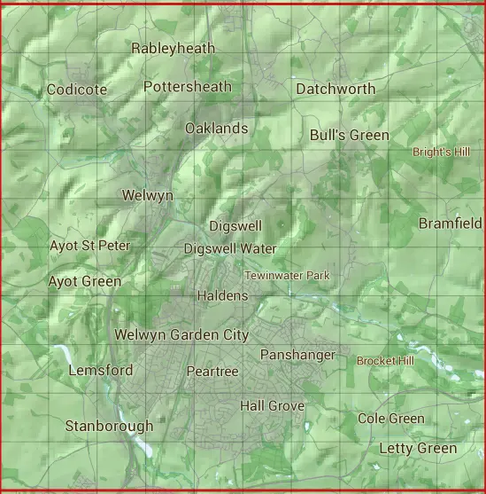
The TL21 10 square kilometre grid intersects with the settlements of Ayot Green,Birch Green,Bramfield,Bull's Green,Burnham Green,Codicote,Codicote Bottom,Cole Green,Datchworth,Harmer Green,Hatfield,Knebworth,Lemsford,Letty Green,Nup End Green,Oaklands,Pottersheath,Rableyheath,Stanborough,Tewin,Tewin Wood,Watton at Stone,Welwyn,Welwyn Garden City & Woolmer Green.
TL21
TL21 is within the post towns of Hatfield, Hertfordshire, Hertford, Hertfordshire, Hitchin, Hertfordshire, Knebworth, Hertfordshire, St. Albans, Hertfordshire, Welwyn Garden City, Hertfordshire & Welwyn, Hertfordshire.
The square is within East Hertfordshire District, North Hertfordshire District, St. Albans District & Welwyn Hatfield District councils.
The TL21 national grid square measures 10 km by 10 km and has an area of 1,000 kilometres squared.
The technical term for a 10 km map square is a Hectad.
When this 10 km square is divided into a grid 10 by 10 it gives the next size of grid square. This unit is called a Monad and measures 1km square. 100 monads fit in a 10km square.
Out of the monads generated from square TL21, 523 are land and -423 are sea. Sea squares are disregarded on this site as they contain no land features.
|
|
|
|
|
|
 |
|
|
|
|
|
 |  |  |  |  |  |  |  |  |  |
 |  |  |  |  |  |  |  |  |  |
 |  |  |  |  |  |  |  |  |  |
 |  |  |  |  |  |  |  |  |  |
 |  |  |  |  |  |  |  |  |  |
 |  |  |  |  |  |  |  |  |  |
 |  |  |  |  |  |  |  |  |  |
 |  |  |  |  |  |  |  |  |  |
 |  |  |  |  |  |  |  |  |  |
 |  |  |  |  |  |  |  |  |  |
| Corner | Latitude | Longitude | Easting | Northing |
|---|---|---|---|---|
| South West Corner | 51.773589 | -0.262059 | 520000 | 210000 |
| South East Corner | 51.773589 | -0.113444 | 530000 | 210000 |
| North West Corner | 51.865689 | -0.262059 | 520000 | 220000 |
| North East Corner | 51.865689 | -0.113444 | 530000 | 220000 |