Search for Grid Square by Postcode
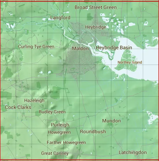
TL80
Based in the Eastern English Region.
The TL80 10 square kilometre grid intersects with the settlements of Broad Street Green,Cock Clarks,Cold Norton,Curling Tye Green,Goldhanger,Great Canney,Hazeleigh,Heybridge Basin,Howegreen,Langford,Latchingdon,Maldon,Maylandsea,Mundon,Purleigh,Roundbush,Rudley Green,Ulting,Woodham Mortimer & Woodham Walter.
TL80
TL80 is within the post towns of Chelmsford, Essex, Maldon, Essex & Witham, Essex.
The square is within Braintree District, Chelmsford District & Maldon District councils.
The TL80 national grid square measures 10 km by 10 km and has an area of 1,000 kilometres squared.
The technical term for a 10 km map square is a Hectad.
When this 10 km square is divided into a grid 10 by 10 it gives the next size of grid square. This unit is called a Monad and measures 1km square. 100 monads fit in a 10km square.
Out of the monads generated from square TL80, 523 are land and -423 are sea. Sea squares are disregarded on this site as they contain no land features.
|
|
|
|
|
|
 |
|
|
|
|
|
 |  |  |  |  |  |  |  |  |  |
 |  |  |  |  |  |  |  |  |  |
 |  |  |  |  |  |  |  |  |  |
 |  |  |  |  |  |  |  |  |  |
 |  |  |  |  |  |  |  |  |  |
 |  |  |  |  |  |  |  |  |  |
 |  |  |  |  |  |  |  |  |  |
 |  |  |  |  |  |  |  |  |  |
 |  |  |  |  |  |  |  |  |  |
 |  |  |  |  |  |  |  |  |  |
| Corner | Latitude | Longitude | Easting | Northing |
|---|---|---|---|---|
| South West Corner | 51.666651 | 0.601633 | 580000 | 200000 |
| South East Corner | 51.666651 | 0.751518 | 590000 | 200000 |
| North West Corner | 51.759761 | 0.601633 | 580000 | 210000 |
| North East Corner | 51.759761 | 0.751518 | 590000 | 210000 |