Search for Grid Square by Postcode
ST64
Based in the South West English Region.
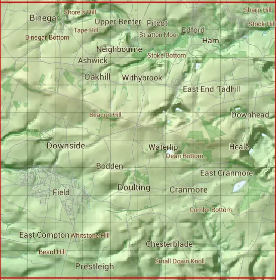
The ST64 10 square kilometre grid intersects with the settlements of Ashwick,Benter,Binegar,Bodden,Cannard's Grave,Chelynch,Chesterblade,Coleford,Cranmore,Dean,Doulting,Downhead,Downside,Gurney Slade,Holcombe,Leigh upon Mendip,Neighbourne,Oakhill,Pilton,Prestleigh,Shepton Mallet,Stoke St Michael,Street & Waterlip.
ST64
ST64 is within the post towns of Frome, Somerset, Radstock, Somerset, Shepton Mallet, Somerset & Wells, Somerset.
The square is within Mendip District council.
The ST64 national grid square measures 10 km by 10 km and has an area of 1,000 kilometres squared.
The technical term for a 10 km map square is a Hectad.
When this 10 km square is divided into a grid 10 by 10 it gives the next size of grid square. This unit is called a Monad and measures 1km square. 100 monads fit in a 10km square.
Out of the monads generated from square ST64, 464 are land and -364 are sea. Sea squares are disregarded on this site as they contain no land features.
|
|
|
|
|
|
 |
|
|
|
|
|
 |  |  |  |  |  |  |  |  |  |
 |  |  |  |  |  |  |  |  |  |
 |  |  |  |  |  |  |  |  |  |
 |  |  |  |  |  |  |  |  |  |
 |  |  |  |  |  |  |  |  |  |
 |  |  |  |  |  |  |  |  |  |
 |  |  |  |  |  |  |  |  |  |
 |  |  |  |  |  |  |  |  |  |
 |  |  |  |  |  |  |  |  |  |
 |  |  |  |  |  |  |  |  |  |
| Corner | Latitude | Longitude | Easting | Northing |
|---|---|---|---|---|
| South West Corner | 51.157839 | -2.574475 | 360000 | 140000 |
| South East Corner | 51.157839 | -2.430366 | 370000 | 140000 |
| North West Corner | 51.248371 | -2.574475 | 360000 | 150000 |
| North East Corner | 51.248371 | -2.430366 | 370000 | 150000 |