Search for Grid Square by Postcode
SO61
Based in the South West English Region & West Midlands English Region.
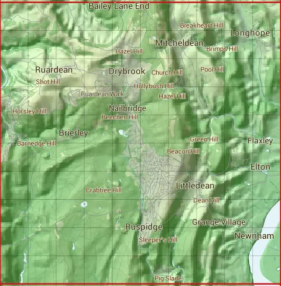
The SO61 10 square kilometre grid intersects with the settlements of Brierley,Broadoak,Cinderford,Drybrook,Dursley Cross,Elton,Grange Village,Hope Mansell,Little London,Littledean,Longhope,Mitcheldean,Newnham,Plump Hill,Pope's Hill,Ruardean,Ruardean Woodside,Ruspidge,Upper Lydbrook & Upper Soudley.
SO61
SO61 is within the post towns of Cinderford, Gloucestershire, Coleford, Gloucestershire, Gloucester, Gloucestershire, Lydney, Gloucestershire, Mitcheldean, Gloucestershire, Ross-on-wye, Herefordshire, Ruardean, Gloucestershire & Westbury-on-severn, Gloucestershire.
The square is within County of Herefordshire, Forest of Dean District & Stroud District councils.
The SO61 national grid square measures 10 km by 10 km and has an area of 1,000 kilometres squared.
The technical term for a 10 km map square is a Hectad.
When this 10 km square is divided into a grid 10 by 10 it gives the next size of grid square. This unit is called a Monad and measures 1km square. 100 monads fit in a 10km square.
Out of the monads generated from square SO61, 523 are land and -423 are sea. Sea squares are disregarded on this site as they contain no land features.
|
|
|
|
|
|
 |
|
|
|
|
|
 |  |  |  |  |  |  |  |  |  |
 |  |  |  |  |  |  |  |  |  |
 |  |  |  |  |  |  |  |  |  |
 |  |  |  |  |  |  |  |  |  |
 |  |  |  |  |  |  |  |  |  |
 |  |  |  |  |  |  |  |  |  |
 |  |  |  |  |  |  |  |  |  |
 |  |  |  |  |  |  |  |  |  |
 |  |  |  |  |  |  |  |  |  |
 |  |  |  |  |  |  |  |  |  |
| Corner | Latitude | Longitude | Easting | Northing |
|---|---|---|---|---|
| South West Corner | 51.787224 | -2.582464 | 360000 | 210000 |
| South East Corner | 51.787224 | -2.436334 | 370000 | 210000 |
| North West Corner | 51.877761 | -2.582464 | 360000 | 220000 |
| North East Corner | 51.877761 | -2.436334 | 370000 | 220000 |