Search for Grid Square by Postcode
SP25
Based in the West Midlands English Region.
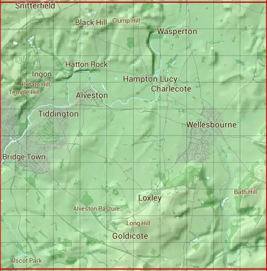
The SP25 10 square kilometre grid intersects with the settlements of Alveston,Atherstone on Stour,Barford,Black Hill,Charlecote,Goldicote,Hampton Lucy,Loxley,Snitterfield,Stratford-upon-Avon,Tiddington,Wasperton & Wellesbourne.
SP25
SP25 is within the post towns of Leamington Spa, Warwickshire, Stratford-upon-avon, Warwickshire & Warwick, Warwickshire.
The square is within Stratford-on-Avon District & Warwick District councils.
The SP25 national grid square measures 10 km by 10 km and has an area of 1,000 kilometres squared.
The technical term for a 10 km map square is a Hectad.
When this 10 km square is divided into a grid 10 by 10 it gives the next size of grid square. This unit is called a Monad and measures 1km square. 100 monads fit in a 10km square.
Out of the monads generated from square SP25, 523 are land and -423 are sea. Sea squares are disregarded on this site as they contain no land features.
|
|
|
|
|
|
 |
|
|
|
|
|
 |  |  |  |  |  |  |  |  |  |
 |  |  |  |  |  |  |  |  |  |
 |  |  |  |  |  |  |  |  |  |
 |  |  |  |  |  |  |  |  |  |
 |  |  |  |  |  |  |  |  |  |
 |  |  |  |  |  |  |  |  |  |
 |  |  |  |  |  |  |  |  |  |
 |  |  |  |  |  |  |  |  |  |
 |  |  |  |  |  |  |  |  |  |
 |  |  |  |  |  |  |  |  |  |
| Corner | Latitude | Longitude | Easting | Northing |
|---|---|---|---|---|
| South West Corner | 52.147492 | -1.709119 | 420000 | 250000 |
| South East Corner | 52.147492 | -1.562096 | 430000 | 250000 |
| North West Corner | 52.237845 | -1.709119 | 420000 | 260000 |
| North East Corner | 52.237845 | -1.562096 | 430000 | 260000 |