Search for Grid Square by Postcode
SK21
Based in the East Midlands English Region & West Midlands English Region.
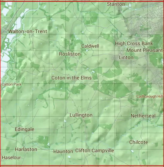
The SK21 10 square kilometre grid intersects with the settlements of Acresford,Barton Turn,Burton upon Trent,Caldwell,Castle Gresley,Chilcote,Clifton Campville,Coton in the Elms,Edingale,Harlaston,Haunton,High Cross Bank,Linton,Lullington,Mount Pleasant,Netherseal,Overseal,Rosliston,Stanton,Swadlincote & Walton-on-Trent.
SK21
SK21 is within the post towns of Burton-on-trent, Staffordshire, Lichfield, Staffordshire, Swadlincote, Derbyshire & Tamworth, Staffordshire.
The square is within East Staffordshire District, Lichfield District, North Warwickshire District, North West Leicestershire District & South Derbyshire District councils.
The SK21 national grid square measures 10 km by 10 km and has an area of 1,000 kilometres squared.
The technical term for a 10 km map square is a Hectad.
When this 10 km square is divided into a grid 10 by 10 it gives the next size of grid square. This unit is called a Monad and measures 1km square. 100 monads fit in a 10km square.
Out of the monads generated from square SK21, 523 are land and -423 are sea. Sea squares are disregarded on this site as they contain no land features.
|
|
|
|
|
|
 |
|
|
|
|
|
 |  |  |  |  |  |  |  |  |  |
 |  |  |  |  |  |  |  |  |  |
 |  |  |  |  |  |  |  |  |  |
 |  |  |  |  |  |  |  |  |  |
 |  |  |  |  |  |  |  |  |  |
 |  |  |  |  |  |  |  |  |  |
 |  |  |  |  |  |  |  |  |  |
 |  |  |  |  |  |  |  |  |  |
 |  |  |  |  |  |  |  |  |  |
 |  |  |  |  |  |  |  |  |  |
| Corner | Latitude | Longitude | Easting | Northing |
|---|---|---|---|---|
| South West Corner | 52.686882 | -1.705555 | 420000 | 310000 |
| South East Corner | 52.686882 | -1.556712 | 430000 | 310000 |
| North West Corner | 52.777236 | -1.705555 | 420000 | 320000 |
| North East Corner | 52.777236 | -1.556712 | 430000 | 320000 |