Search for Grid Square by Postcode
SO80
Based in the South West English Region.
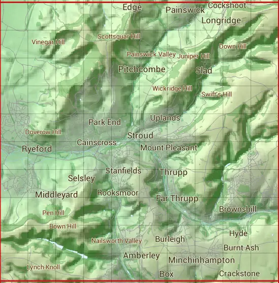
The SO80 10 square kilometre grid intersects with the settlements of Amberley,Bagpath,Bownham,Box,Brimscombe,Butterrow,Chalford,Eastcombe,Edge,Far Thrupp,France Lynch,Haresfield,Houndscroft,King's Stanley,Knave-in-hole,Leonard Stanley,Littleworth,Middleyard,Minchinhampton,Nailsworth,Nympsfield,Painswick,Pitchcombe,Randwick,Ruscombe,Ryeford,Selsley,Selsley West,Sheepscombe,Slad,St Chloe,Stancombe,Stanley Downton,Stonehouse,Stroud,Stroud Green,Theescombe,Thrupp,Whiteshill & Woodchester.
SO80
SO80 is within the post towns of Gloucester, Gloucestershire, Stonehouse, Gloucestershire & Stroud, Gloucestershire.
The square is within Stroud District council.
The SO80 national grid square measures 10 km by 10 km and has an area of 1,000 kilometres squared.
The technical term for a 10 km map square is a Hectad.
When this 10 km square is divided into a grid 10 by 10 it gives the next size of grid square. This unit is called a Monad and measures 1km square. 100 monads fit in a 10km square.
Out of the monads generated from square SO80, 523 are land and -423 are sea. Sea squares are disregarded on this site as they contain no land features.
|
|
|
|
|
|
 |
|
|
|
|
|
 |  |  |  |  |  |  |  |  |  |
 |  |  |  |  |  |  |  |  |  |
 |  |  |  |  |  |  |  |  |  |
 |  |  |  |  |  |  |  |  |  |
 |  |  |  |  |  |  |  |  |  |
 |  |  |  |  |  |  |  |  |  |
 |  |  |  |  |  |  |  |  |  |
 |  |  |  |  |  |  |  |  |  |
 |  |  |  |  |  |  |  |  |  |
 |  |  |  |  |  |  |  |  |  |
| Corner | Latitude | Longitude | Easting | Northing |
|---|---|---|---|---|
| South West Corner | 51.698388 | -2.291357 | 380000 | 200000 |
| South East Corner | 51.698388 | -2.146086 | 390000 | 200000 |
| North West Corner | 51.788571 | -2.291357 | 380000 | 210000 |
| North East Corner | 51.788571 | -2.146086 | 390000 | 210000 |