Search for Grid Square by Postcode
SH81
Based in the Mid and West Wales region of Scotland.
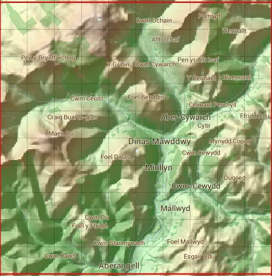
The SH81 10 square kilometre grid intersects with the settlements of Aberangell,Dinas Mawddwy & Minllyn.
SH81
SH81 is within the post towns of Dolgellau, Merioneth & Machynlleth, Montgomeryshire.
The square is within Gwynedd - Gwynedd & Powys - Powys councils.
The SH81 national grid square measures 10 km by 10 km and has an area of 1,000 kilometres squared.
The technical term for a 10 km map square is a Hectad.
When this 10 km square is divided into a grid 10 by 10 it gives the next size of grid square. This unit is called a Monad and measures 1km square. 100 monads fit in a 10km square.
Out of the monads generated from square SH81, 327 are land and -227 are sea. Sea squares are disregarded on this site as they contain no land features.
|
|
|
|
|
|
 |
|
|
|
|
|
 |  |  |  |  |  |  |  |  |  |
 |  |  |  |  |  |  |  |  |  |
 |  |  |  |  |  |  |  |  |  |
 |  |  |  |  |  |  |  |  |  |
 |  |  |  |  |  |  |  |  |  |
 |  |  |  |  |  |  |  |  |  |
 |  |  |  |  |  |  |  |  |  |
 |  |  |  |  |  |  |  |  |  |
 |  |  |  |  |  |  |  |  |  |
 |  |  |  |  |  |  |  |  |  |
| Corner | Latitude | Longitude | Easting | Northing |
|---|---|---|---|---|
| South West Corner | 52.674391 | -3.779897 | 280000 | 310000 |
| South East Corner | 52.674391 | -3.628409 | 290000 | 310000 |
| North West Corner | 52.766374 | -3.779897 | 280000 | 320000 |
| North East Corner | 52.766374 | -3.628409 | 290000 | 320000 |