Search for Grid Square by Postcode
SK47
Based in the East Midlands English Region & Yorkshire and the Humber English Region.
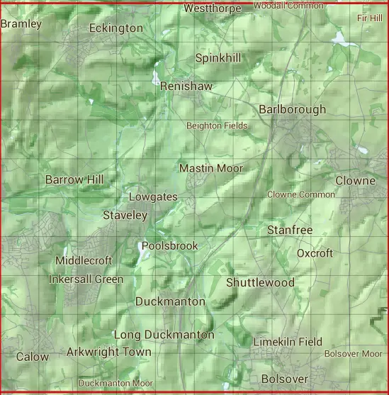
The SK47 10 square kilometre grid intersects with the settlements of Arkwright Town,Barlborough,Barrow Hill,Bolehill,Bolsover,Bramley,Brimington,Calow,Chesterfield,Clowne,Cock Alley,Duckmanton,Eckington,Harthill,Killamarsh,Long Duckmanton,Markham Vale,Marsh Lane,Middle Handley,Oxcroft,Oxcroft Estate,Renishaw,Sheffield,Shuttlewood,Spinkhill,Stanfree,Staveley & Woodthorpe.
SK47
SK47 is within the post towns of Chesterfield, Derbyshire, Mansfield, Nottinghamshire, Sheffield, Yorkshire & Worksop, Nottinghamshire.
The square is within Bolsover District, Chesterfield District, North East Derbyshire District, Rotherham District & Sheffield District councils.
The SK47 national grid square measures 10 km by 10 km and has an area of 1,000 kilometres squared.
The technical term for a 10 km map square is a Hectad.
When this 10 km square is divided into a grid 10 by 10 it gives the next size of grid square. This unit is called a Monad and measures 1km square. 100 monads fit in a 10km square.
Out of the monads generated from square SK47, 523 are land and -423 are sea. Sea squares are disregarded on this site as they contain no land features.
|
|
|
|
|
|
 |
|
|
|
|
|
 |  |  |  |  |  |  |  |  |  |
 |  |  |  |  |  |  |  |  |  |
 |  |  |  |  |  |  |  |  |  |
 |  |  |  |  |  |  |  |  |  |
 |  |  |  |  |  |  |  |  |  |
 |  |  |  |  |  |  |  |  |  |
 |  |  |  |  |  |  |  |  |  |
 |  |  |  |  |  |  |  |  |  |
 |  |  |  |  |  |  |  |  |  |
 |  |  |  |  |  |  |  |  |  |
| Corner | Latitude | Longitude | Easting | Northing |
|---|---|---|---|---|
| South West Corner | 53.224720 | -1.402311 | 440000 | 370000 |
| South East Corner | 53.224720 | -1.250970 | 450000 | 370000 |
| North West Corner | 53.315447 | -1.402311 | 440000 | 380000 |
| North East Corner | 53.315447 | -1.250970 | 450000 | 380000 |