Search for Grid Square by Postcode
SK25
Based in the East Midlands English Region.
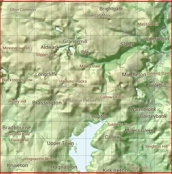
The SK25 10 square kilometre grid intersects with the settlements of Ashleyhay,Bolehill,Bonsall,Brassington,Callow,Carsington,Cromford,Grangemill,Hognaston,Ible,Kirk Ireton,Kniveton,Matlock,Matlock Bath,Middleton,Slaley,Starkholmes,Upper Town & Wirksworth.
SK25
SK25 is within the post towns of Ashbourne, Derbyshire, Belper, Derbyshire & Matlock, Derbyshire.
The square is within Amber Valley District & Derbyshire Dales District councils.
The SK25 national grid square measures 10 km by 10 km and has an area of 1,000 kilometres squared.
The technical term for a 10 km map square is a Hectad.
When this 10 km square is divided into a grid 10 by 10 it gives the next size of grid square. This unit is called a Monad and measures 1km square. 100 monads fit in a 10km square.
Out of the monads generated from square SK25, 523 are land and -423 are sea. Sea squares are disregarded on this site as they contain no land features.
|
|
|
|
|
|
 |
|
|
|
|
|
 |  |  |  |  |  |  |  |  |  |
 |  |  |  |  |  |  |  |  |  |
 |  |  |  |  |  |  |  |  |  |
 |  |  |  |  |  |  |  |  |  |
 |  |  |  |  |  |  |  |  |  |
 |  |  |  |  |  |  |  |  |  |
 |  |  |  |  |  |  |  |  |  |
 |  |  |  |  |  |  |  |  |  |
 |  |  |  |  |  |  |  |  |  |
 |  |  |  |  |  |  |  |  |  |
| Corner | Latitude | Longitude | Easting | Northing |
|---|---|---|---|---|
| South West Corner | 53.046447 | -1.703116 | 420000 | 350000 |
| South East Corner | 53.046447 | -1.553026 | 430000 | 350000 |
| North West Corner | 53.136801 | -1.703116 | 420000 | 360000 |
| North East Corner | 53.136801 | -1.553026 | 430000 | 360000 |