Search for Grid Square by Postcode
SH97
Based in the North Wales region of Scotland.
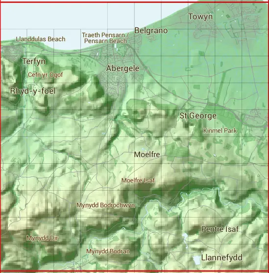
The SH97 10 square kilometre grid intersects with the settlements of Abergele,Belgrano,Betws-yn-Rhos,Bodelwyddan,Glascoed,Kinmel Bay,Llanddulas,Llanfair Talhaiarn,Llannefydd,Llansan Sior,Pensarn,Rhyd-y-foel,Terfyn & Towyn.
SH97
SH97 is within the post towns of Abergele, Denbighshire, Colwyn Bay, Denbighshire, Denbigh, Denbighshire, Rhyl, Flintshire & St. Asaph, Flintshire.
The square is within Conwy - Conwy & Sir Ddinbych - Denbighshire councils.
The SH97 national grid square measures 10 km by 10 km and has an area of 1,000 kilometres squared.
The technical term for a 10 km map square is a Hectad.
When this 10 km square is divided into a grid 10 by 10 it gives the next size of grid square. This unit is called a Monad and measures 1km square. 100 monads fit in a 10km square.
Out of the monads generated from square SH97, 320 are land and -220 are sea. Sea squares are disregarded on this site as they contain no land features.
|
|
|
|
|
|
 |
|
|
|
|
|
 |  |  |  |  |  | ||||
 |  |  |  |  |  |  |  |  |  |
 |  |  |  |  |  |  |  |  |  |
 |  |  |  |  |  |  |  |  |  |
 |  |  |  |  |  |  |  |  |  |
 |  |  |  |  |  |  |  |  |  |
 |  |  |  |  |  |  |  |  |  |
 |  |  |  |  |  |  |  |  |  |
 |  |  |  |  |  |  |  |  |  |
 |  |  |  |  |  |  |  |  |  |
| Corner | Latitude | Longitude | Easting | Northing |
|---|---|---|---|---|
| South West Corner | 53.215650 | -3.652247 | 290000 | 370000 |
| South East Corner | 53.215650 | -3.499087 | 300000 | 370000 |
| North West Corner | 53.307486 | -3.652247 | 290000 | 380000 |
| North East Corner | 53.307486 | -3.499087 | 300000 | 380000 |