Search for Grid Square by Postcode
SH63
Based in the Mid and West Wales region of Scotland.
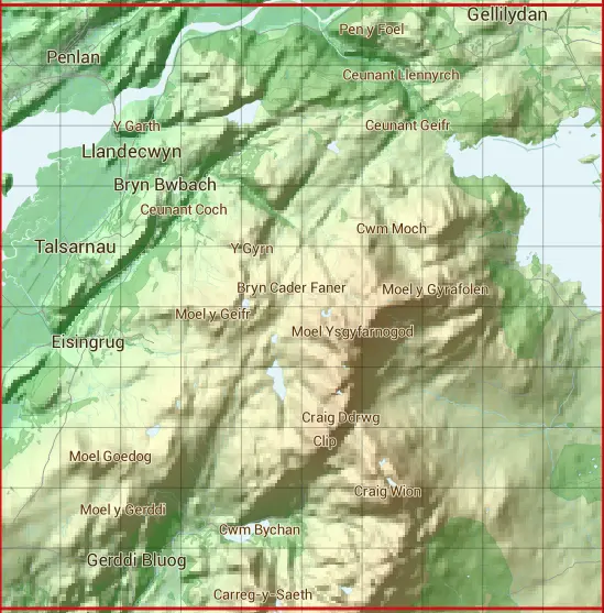
The SH63 10 square kilometre grid intersects with the settlements of Eisingrug,Gellilydan,Llandecwyn,Minffordd,Penrhyndeudraeth,Talsarnau & Ynys.
SH63
SH63 is within the post towns of Blaenau Ffestiniog, Merioneth, Harlech, Merioneth, Llanbedr, Merioneth, Penrhyndeudraeth, Merioneth & Talsarnau, Merioneth.
The square is within Gwynedd - Gwynedd council.
The SH63 national grid square measures 10 km by 10 km and has an area of 1,000 kilometres squared.
The technical term for a 10 km map square is a Hectad.
When this 10 km square is divided into a grid 10 by 10 it gives the next size of grid square. This unit is called a Monad and measures 1km square. 100 monads fit in a 10km square.
Out of the monads generated from square SH63, 379 are land and -279 are sea. Sea squares are disregarded on this site as they contain no land features.
|
|
|
|
|
|
 |
|
|
|
|
|
 |  |  |  |  |  |  |  |  |  |
 |  |  |  |  |  |  |  |  |  |
 |  |  |  |  |  |  |  |  |  |
 |  |  |  |  |  |  |  |  |  |
 |  |  |  |  |  |  |  |  |  |
 |  |  |  |  |  |  |  |  |  |
 |  |  |  |  |  |  |  |  |  |
 |  |  |  |  |  |  |  |  |  |
 |  |  |  |  |  |  |  |  |  |
 |  |  |  |  |  |  |  |  |  |
| Corner | Latitude | Longitude | Easting | Northing |
|---|---|---|---|---|
| South West Corner | 52.849264 | -4.084702 | 260000 | 330000 |
| South East Corner | 52.849264 | -3.931993 | 270000 | 330000 |
| North West Corner | 52.941614 | -4.084702 | 260000 | 340000 |
| North East Corner | 52.941614 | -3.931993 | 270000 | 340000 |