Search for Grid Square by Postcode
SD86
Based in the Yorkshire and the Humber English Region.
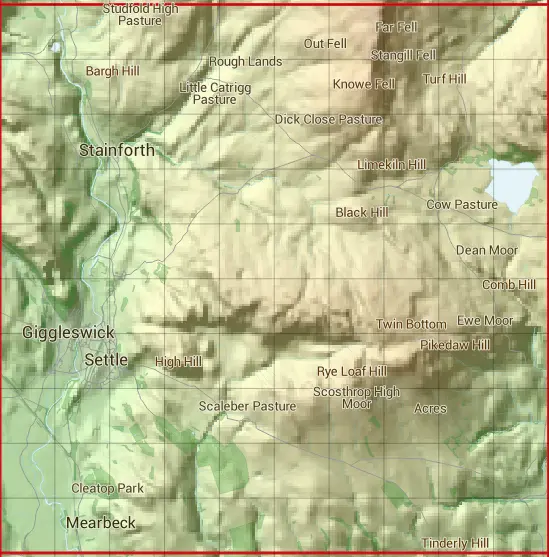
The SD86 10 square kilometre grid intersects with the settlements of Giggleswick,Kirkby Malham,Langcliffe,Malham,Rathmell,Settle & Stainforth.
SD86
SD86 is within the post towns of Lancaster, Lancashire, Settle, Yorkshire & Skipton, Yorkshire.
The square is within Craven District council.
The SD86 national grid square measures 10 km by 10 km and has an area of 1,000 kilometres squared.
The technical term for a 10 km map square is a Hectad.
When this 10 km square is divided into a grid 10 by 10 it gives the next size of grid square. This unit is called a Monad and measures 1km square. 100 monads fit in a 10km square.
Out of the monads generated from square SD86, 465 are land and -365 are sea. Sea squares are disregarded on this site as they contain no land features.
|
|
|
|
|
|
 |
|
|
|
|
|
 |  |  |  |  |  |  |  |  |  |
 |  |  |  |  |  |  |  |  |  |
 |  |  |  |  |  |  |  |  |  |
 |  |  |  |  |  |  |  |  |  |
 |  |  |  |  |  |  |  |  |  |
 |  |  |  |  |  |  |  |  |  |
 |  |  |  |  |  |  |  |  |  |
 |  |  |  |  |  |  |  |  |  |
 |  |  |  |  |  |  |  |  |  |
 |  |  |  |  |  |  |  |  |  |
| Corner | Latitude | Longitude | Easting | Northing |
|---|---|---|---|---|
| South West Corner | 54.035603 | -2.307523 | 380000 | 460000 |
| South East Corner | 54.035603 | -2.154178 | 390000 | 460000 |
| North West Corner | 54.125771 | -2.307523 | 380000 | 470000 |
| North East Corner | 54.125771 | -2.154178 | 390000 | 470000 |