Search for Grid Square by Postcode
SD67
Based in the North West English Region & Yorkshire and the Humber English Region.
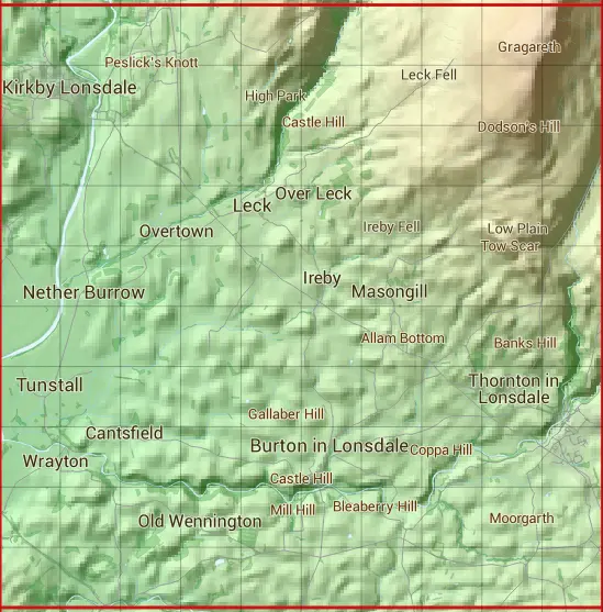
The SD67 10 square kilometre grid intersects with the settlements of Burton in Lonsdale,Casterton,High Bentham,Ingleton,Ireby,Kearstwick,Kirkby Lonsdale,Leck,Low Biggins,Melling,Nether Burrow,Tunstall,Wennington & Whittington.
SD67
SD67 is within the post towns of Carnforth, Lancashire & Lancaster, Lancashire.
The square is within Craven District, Lancaster District & South Lakeland District councils.
The SD67 national grid square measures 10 km by 10 km and has an area of 1,000 kilometres squared.
The technical term for a 10 km map square is a Hectad.
When this 10 km square is divided into a grid 10 by 10 it gives the next size of grid square. This unit is called a Monad and measures 1km square. 100 monads fit in a 10km square.
Out of the monads generated from square SD67, 471 are land and -371 are sea. Sea squares are disregarded on this site as they contain no land features.
|
|
|
|
|
|
 |
|
|
|
|
|
 |  |  |  |  |  |  |  |  |  |
 |  |  |  |  |  |  |  |  |  |
 |  |  |  |  |  |  |  |  |  |
 |  |  |  |  |  |  |  |  |  |
 |  |  |  |  |  |  |  |  |  |
 |  |  |  |  |  |  |  |  |  |
 |  |  |  |  |  |  |  |  |  |
 |  |  |  |  |  |  |  |  |  |
 |  |  |  |  |  |  |  |  |  |
 |  |  |  |  |  |  |  |  |  |
| Corner | Latitude | Longitude | Easting | Northing |
|---|---|---|---|---|
| South West Corner | 54.124304 | -2.614863 | 360000 | 470000 |
| South East Corner | 54.124304 | -2.460531 | 370000 | 470000 |
| North West Corner | 54.214857 | -2.614863 | 360000 | 480000 |
| North East Corner | 54.214857 | -2.460531 | 370000 | 480000 |