Search for Grid Square by Postcode
SD42
Based in the North West English Region.
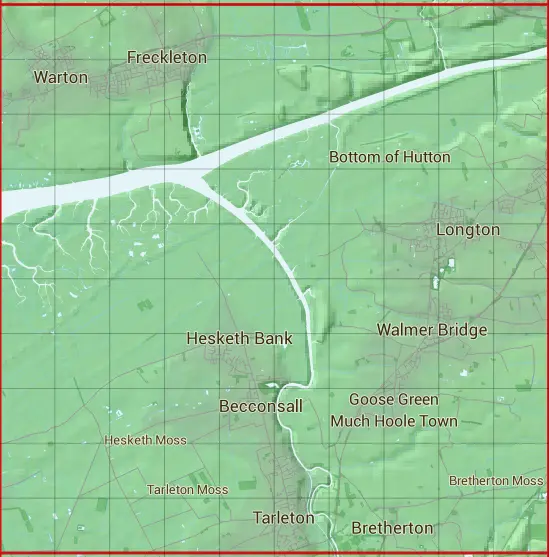
The SD42 10 square kilometre grid intersects with the settlements of Banks,Becconsall,Bottom of Hutton,Bretherton,Freckleton,Hesketh Bank,Hundred End,Hutton,Little Hoole Moss Houses,Longton,Much Hoole,Preston,Tarleton,Walmer Bridge & Warton.
SD42
SD42 is within the post towns of Leyland, Lancashire, Preston, Lancashire & Southport, Lancashire.
The square is within Chorley District, Fylde District, Preston District, South Ribble District & West Lancashire District councils.
The SD42 national grid square measures 10 km by 10 km and has an area of 1,000 kilometres squared.
The technical term for a 10 km map square is a Hectad.
When this 10 km square is divided into a grid 10 by 10 it gives the next size of grid square. This unit is called a Monad and measures 1km square. 100 monads fit in a 10km square.
Out of the monads generated from square SD42, 432 are land and -332 are sea. Sea squares are disregarded on this site as they contain no land features.
|
|
|
|
|
|
 |
|
|
|
|
|
 |  |  |  |  |  |  |  |  |  |
 |  |  |  |  |  |  |  |  |  |
 |  |  |  |  |  |  |  |  |  |
 |  |  |  |  |  |  |  |  |  |
 |  |  |  |  |  |  |  |  |  |
 |  |  |  |  |  |  |  |  |  |
 |  |  |  |  |  |  |  |  |  |
 |  |  |  |  |  |  |  |  |  |
 |  |  |  |  |  |  |  |  |  |
 |  |  |  |  |  |  |  |  |  |
| Corner | Latitude | Longitude | Easting | Northing |
|---|---|---|---|---|
| South West Corner | 53.673026 | -2.911635 | 340000 | 420000 |
| South East Corner | 53.673026 | -2.758340 | 350000 | 420000 |
| North West Corner | 53.763954 | -2.911635 | 340000 | 430000 |
| North East Corner | 53.763954 | -2.758340 | 350000 | 430000 |