Search for Grid Square by Postcode
NU20
Based in the North East English Region.
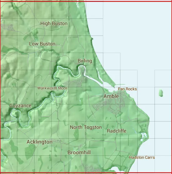
The NU20 10 square kilometre grid intersects with the settlements of Acklington,Amble,Broomhill,Hadston,High Hauxley,Shilbottle,South Broomhill,Togston & Warkworth.
NU20
NU20 is within the post towns of Alnwick, Northumberland & Morpeth, Northumberland.
The square is within Northumberland council.
The NU20 national grid square measures 10 km by 10 km and has an area of 1,000 kilometres squared.
The technical term for a 10 km map square is a Hectad.
When this 10 km square is divided into a grid 10 by 10 it gives the next size of grid square. This unit is called a Monad and measures 1km square. 100 monads fit in a 10km square.
Out of the monads generated from square NU20, 163 are land and -63 are sea. Sea squares are disregarded on this site as they contain no land features.
|
|
|
|
|
|
 |
|
|
|
|
|
 |  |  |  |  |  | ||||
 |  |  |  |  |  | ||||
 |  |  |  |  |  | ||||
 |  |  |  |  |  |  | |||
 |  |  |  |  |  |  |  |  | |
 |  |  |  |  |  |  |  |  |  |
 |  |  |  |  |  |  |  |  |  |
 |  |  |  |  |  |  |  |  |  |
 |  |  |  |  |  |  |  |  |  |
 |  |  |  |  |  |  |  |  |
| Corner | Latitude | Longitude | Easting | Northing |
|---|---|---|---|---|
| South West Corner | 55.293210 | -1.686610 | 420000 | 600000 |
| South East Corner | 55.293210 | -1.528077 | 430000 | 600000 |
| North West Corner | 55.383569 | -1.686610 | 420000 | 610000 |
| North East Corner | 55.383569 | -1.528077 | 430000 | 610000 |