Search for Grid Square by Postcode
NY31
Based in the North West English Region.
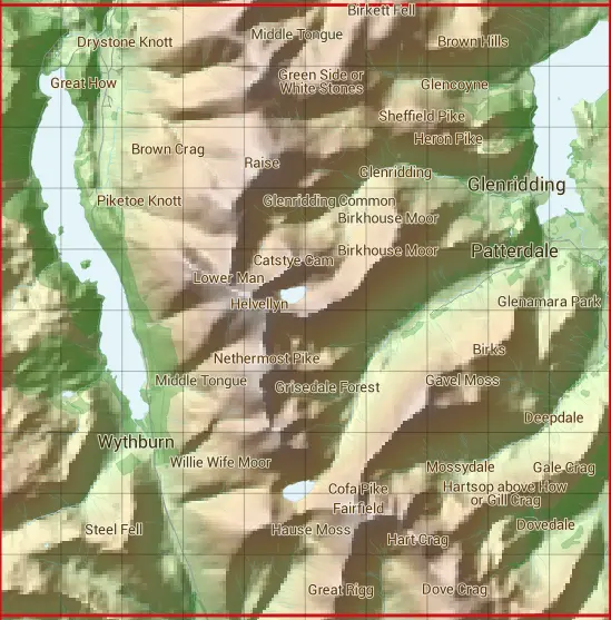
The NY31 10 square kilometre grid intersects with the settlements of Glenridding,Legburthwaite & Patterdale.
NY31
NY31 is within the post towns of Ambleside, Westmorland, Keswick, Cumberland & Penrith, Cumberland.
The square is within Allerdale District, Eden District & South Lakeland District councils.
The NY31 national grid square measures 10 km by 10 km and has an area of 1,000 kilometres squared.
The technical term for a 10 km map square is a Hectad.
When this 10 km square is divided into a grid 10 by 10 it gives the next size of grid square. This unit is called a Monad and measures 1km square. 100 monads fit in a 10km square.
Out of the monads generated from square NY31, 520 are land and -420 are sea. Sea squares are disregarded on this site as they contain no land features.
|
|
|
|
|
|
 |
|
|
|
|
|
 |  |  |  |  |  |  |  |  |  |
 |  |  |  |  |  |  |  |  |  |
 |  |  |  |  |  |  |  |  |  |
 |  |  |  |  |  |  |  |  |  |
 |  |  |  |  |  |  |  |  |  |
 |  |  |  |  |  |  |  |  |  |
 |  |  |  |  |  |  |  |  |  |
 |  |  |  |  |  |  |  |  |  |
 |  |  |  |  |  |  |  |  |  |
 |  |  |  |  |  |  |  |  |  |
| Corner | Latitude | Longitude | Easting | Northing |
|---|---|---|---|---|
| South West Corner | 54.480509 | -3.084255 | 330000 | 510000 |
| South East Corner | 54.480509 | -2.927563 | 340000 | 510000 |
| North West Corner | 54.571648 | -3.084255 | 330000 | 520000 |
| North East Corner | 54.571648 | -2.927563 | 340000 | 520000 |