Search for Grid Square by Postcode
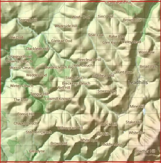
NS81
Based in the South Scotland region of Scotland.
The NS81 10 square kilometre grid intersects with the settlements of Leadhills & Wanlockhead.
NS81
NS81 is within the post towns of Biggar, Lanarkshire, Sanquhar, Dumfriesshire & Thornhill, Dumfriesshire.
The square is within Dumfries and Galloway & South Lanarkshire councils.
The NS81 national grid square measures 10 km by 10 km and has an area of 1,000 kilometres squared.
The technical term for a 10 km map square is a Hectad.
When this 10 km square is divided into a grid 10 by 10 it gives the next size of grid square. This unit is called a Monad and measures 1km square. 100 monads fit in a 10km square.
Out of the monads generated from square NS81, 462 are land and -362 are sea. Sea squares are disregarded on this site as they contain no land features.
|
|
|
|
|
|
 |
|
|
|
|
|
 |  |  |  |  |  |  |  |  |  |
 |  |  |  |  |  |  |  |  |  |
 |  |  |  |  |  |  |  |  |  |
 |  |  |  |  |  |  |  |  |  |
 |  |  |  |  |  |  |  |  |  |
 |  |  |  |  |  |  |  |  |  |
 |  |  |  |  |  |  |  |  |  |
 |  |  |  |  |  |  |  |  |  |
 |  |  |  |  |  |  |  |  |  |
 |  |  |  |  |  |  |  |  |  |
| Corner | Latitude | Longitude | Easting | Northing |
|---|---|---|---|---|
| South West Corner | 55.369282 | -3.899263 | 280000 | 610000 |
| South East Corner | 55.369282 | -3.737259 | 290000 | 610000 |
| North West Corner | 55.461439 | -3.899263 | 280000 | 620000 |
| North East Corner | 55.461439 | -3.737259 | 290000 | 620000 |