Search for Grid Square by Postcode
NO04
Based in the Mid Scotland and Fife region of Scotland.
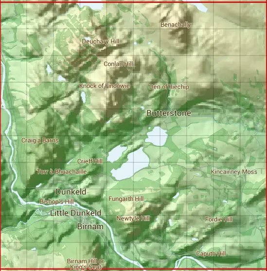
The NO04 10 square kilometre grid intersects with the settlements of Birnam,Butterstone,Caputh,Dowally,Dunkeld,Forneth,Guay & Little Dunkeld.
NO04
NO04 is within the post towns of Blairgowrie, Perthshire, Dunkeld, Perthshire, Perth, Perthshire & Pitlochry, Perthshire.
The square is within Perth and Kinross council.
The NO04 national grid square measures 10 km by 10 km and has an area of 1,000 kilometres squared.
The technical term for a 10 km map square is a Hectad.
When this 10 km square is divided into a grid 10 by 10 it gives the next size of grid square. This unit is called a Monad and measures 1km square. 100 monads fit in a 10km square.
Out of the monads generated from square NO04, 408 are land and -308 are sea. Sea squares are disregarded on this site as they contain no land features.
|
|
|
|
|
|
 |
|
|
|
|
|
 |  |  |  |  |  |  |  |  |  |
 |  |  |  |  |  |  |  |  |  |
 |  |  |  |  |  |  |  |  |  |
 |  |  |  |  |  |  |  |  |  |
 |  |  |  |  |  |  |  |  |  |
 |  |  |  |  |  |  |  |  |  |
 |  |  |  |  |  |  |  |  |  |
 |  |  |  |  |  |  |  |  |  |
 |  |  |  |  |  |  |  |  |  |
 |  |  |  |  |  |  |  |  |  |
| Corner | Latitude | Longitude | Easting | Northing |
|---|---|---|---|---|
| South West Corner | 56.541312 | -3.631700 | 300000 | 740000 |
| South East Corner | 56.541312 | -3.465276 | 310000 | 740000 |
| North West Corner | 56.633143 | -3.631700 | 300000 | 750000 |
| North East Corner | 56.633143 | -3.465276 | 310000 | 750000 |