Search for Grid Square by Postcode
NN59
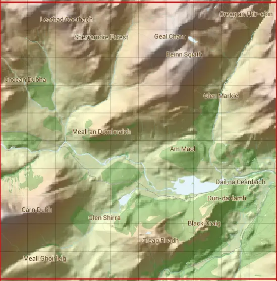
Based in the Highlands and Islands region of Scotland.
NN59
NN59 is within the post towns of Fort Augustus, Inverness-shire & Newtonmore, Inverness-shire.
The square is within Highland council.
The NN59 national grid square measures 10 km by 10 km and has an area of 1,000 kilometres squared.
The technical term for a 10 km map square is a Hectad.
When this 10 km square is divided into a grid 10 by 10 it gives the next size of grid square. This unit is called a Monad and measures 1km square. 100 monads fit in a 10km square.
Out of the monads generated from square NN59, 521 are land and -421 are sea. Sea squares are disregarded on this site as they contain no land features.
|
|
|
|
|
|
 |
|
|
|
|
|
 |  |  |  |  |  |  |  |  |  |
 |  |  |  |  |  |  |  |  |  |
 |  |  |  |  |  |  |  |  |  |
 |  |  |  |  |  |  |  |  |  |
 |  |  |  |  |  |  |  |  |  |
 |  |  |  |  |  |  |  |  |  |
 |  |  |  |  |  |  |  |  |  |
 |  |  |  |  |  |  |  |  |  |
 |  |  |  |  |  |  |  |  |  |
 |  |  |  |  |  |  |  |  |  |
| Corner | Latitude | Longitude | Easting | Northing |
|---|---|---|---|---|
| South West Corner | 56.976771 | -4.475506 | 250000 | 790000 |
| South East Corner | 56.976771 | -4.305171 | 260000 | 790000 |
| North West Corner | 57.069668 | -4.475506 | 250000 | 800000 |
| North East Corner | 57.069668 | -4.305171 | 260000 | 800000 |
1 KM Squares within the NN59 10 KM Square
NN5090 NN5091 NN5092 NN5093 NN5094 NN5095 NN5096 NN5097 NN5098 NN5099 NN5190 NN5191 NN5192 NN5193 NN5194 NN5195 NN5196 NN5197 NN5198 NN5199 NN5290 NN5291 NN5292 NN5293 NN5294 NN5295 NN5296 NN5297 NN5298 NN5299 NN5390 NN5391 NN5392
NN5393 NN5394 NN5395 NN5396 NN5397 NN5398 NN5399 NN5490 NN5491 NN5492 NN5493 NN5494 NN5495 NN5496 NN5497 NN5498 NN5499 NN5590 NN5591 NN5592 NN5593 NN5594 NN5595 NN5596 NN5597 NN5598 NN5599 NN5690 NN5691 NN5692 NN5693 NN5694 NN5695