Search for Grid Square by Postcode
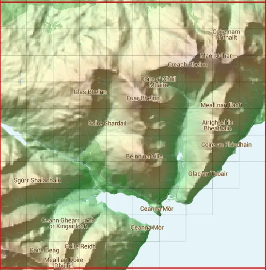
NM85
Based in the Highlands and Islands region of Scotland.
NM85
NM85 is within the post towns of Fort William, Inverness-shire & Oban, Argyllshire.
The square is within Highland council.
The NM85 national grid square measures 10 km by 10 km and has an area of 1,000 kilometres squared.
The technical term for a 10 km map square is a Hectad.
When this 10 km square is divided into a grid 10 by 10 it gives the next size of grid square. This unit is called a Monad and measures 1km square. 100 monads fit in a 10km square.
Out of the monads generated from square NM85, 344 are land and -244 are sea. Sea squares are disregarded on this site as they contain no land features.
|
|
|
|
|
|
 |
|
|
|
|
|
 |  |  |  |  |  |  |  |  |  |
 |  |  |  |  |  |  |  |  |  |
 |  |  |  |  |  |  |  |  |  |
 |  |  |  |  |  |  |  |  |  |
 |  |  |  |  |  |  |  |  |  |
 |  |  |  |  |  |  |  |  |  |
 |  |  |  |  |  |  |  |  | |
 |  |  |  |  |  |  |  | ||
 |  |  |  |  |  |  | |||
 |  |  |  |  |  |
| Corner | Latitude | Longitude | Easting | Northing |
|---|---|---|---|---|
| South West Corner | 56.590138 | -5.593164 | 180000 | 750000 |
| South East Corner | 56.590138 | -5.422112 | 190000 | 750000 |
| North West Corner | 56.684397 | -5.593164 | 180000 | 760000 |
| North East Corner | 56.684397 | -5.422112 | 190000 | 760000 |
1 KM Squares within the NM85 10 KM Square
NM8050 NM8051 NM8052 NM8053 NM8054 NM8055 NM8056 NM8057 NM8058 NM8059 NM8150 NM8151 NM8152 NM8153 NM8154 NM8155 NM8156 NM8157 NM8158 NM8159 NM8250 NM8251 NM8252 NM8253 NM8254 NM8255 NM8256 NM8257 NM8258 NM8259