Search for Grid Square by Postcode
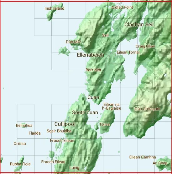
NM71
Based in the Highlands and Islands region of Scotland.
The NM71 10 square kilometre grid intersects with the settlements of Balvicar,Clachan Seil & Ellenabeich.
NM71
NM71 is within the post town of Oban, Argyllshire.
The square is within Argyll and Bute council.
The NM71 national grid square measures 10 km by 10 km and has an area of 1,000 kilometres squared.
The technical term for a 10 km map square is a Hectad.
When this 10 km square is divided into a grid 10 by 10 it gives the next size of grid square. This unit is called a Monad and measures 1km square. 100 monads fit in a 10km square.
Out of the monads generated from square NM71, 284 are land and -184 are sea. Sea squares are disregarded on this site as they contain no land features.
|
|
|
|
|
|
 |
|
|
|
|
|
 |  |  |  |  |  |  |  | ||
 |  |  |  |  |  |  |  | ||
 |  |  |  |  |  |  | |||
 |  |  |  |  |  |  | |||
 |  |  |  |  |  | ||||
 |  |  |  |  |  | ||||
 |  |  |  |  |  |  |  | ||
 |  |  |  |  |  |  |  |  | |
 |  |  |  |  |  |  | |||
 |  |  |  |  |  |  |  |  |
| Corner | Latitude | Longitude | Easting | Northing |
|---|---|---|---|---|
| South West Corner | 56.226745 | -5.720698 | 170000 | 710000 |
| South East Corner | 56.226745 | -5.551029 | 180000 | 710000 |
| North West Corner | 56.321144 | -5.720698 | 170000 | 720000 |
| North East Corner | 56.321144 | -5.551029 | 180000 | 720000 |
1 KM Squares within the NM71 10 KM Square
NM7010 NM7110 NM7111 NM7112 NM7113 NM7210 NM7211 NM7212 NM7218 NM7219 NM7310 NM7311 NM7312 NM7313 NM7316 NM7317 NM7318 NM7319 NM7410 NM7411 NM7412 NM7413 NM7414 NM7415 NM7416