Search for Grid Square by Postcode
NG99
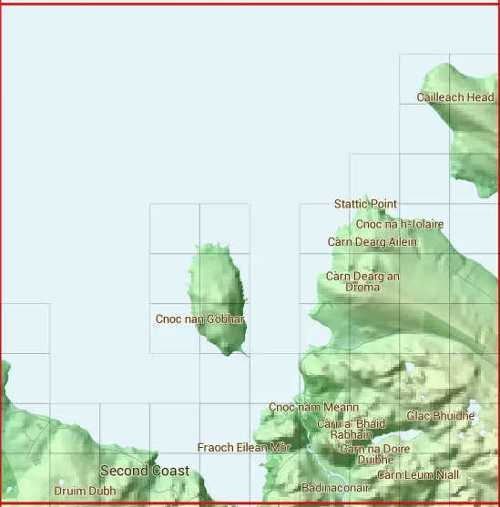
Based in the Highlands and Islands region of Scotland.
The NG99 10 square kilometre grid intersects with the settlement of Laide.
NG99
NG99 is within the post towns of Achnasheen, Ross-shire & Garve, Ross-shire.
The square is within Highland council.
The NG99 national grid square measures 10 km by 10 km and has an area of 1,000 kilometres squared.
The technical term for a 10 km map square is a Hectad.
When this 10 km square is divided into a grid 10 by 10 it gives the next size of grid square. This unit is called a Monad and measures 1km square. 100 monads fit in a 10km square.
Out of the monads generated from square NG99, 840 are land and -740 are sea. Sea squares are disregarded on this site as they contain no land features.
|
|
|
|
|
|
 |
|
|
|
|
|
 |  | ||||||||
 |  | ||||||||
 |  |  | |||||||
 |  |  |  |  |  | ||||
 |  |  |  |  |  | ||||
 |  |  |  |  |  |  | |||
 |  |  |  |  |  |  | |||
 |  |  |  |  |  |  |  |  |  |
 |  |  |  |  |  |  |  |  |  |
| Corner | Latitude | Longitude | Easting | Northing |
|---|---|---|---|---|
| South West Corner | 57.849999 | -5.549348 | 190000 | 890000 |
| South East Corner | 57.849999 | -5.372336 | 200000 | 890000 |
| North West Corner | 57.944248 | -5.549348 | 190000 | 900000 |
| North East Corner | 57.944248 | -5.372336 | 200000 | 900000 |
1 KM Squares within the NG99 10 KM Square
NG9090 NG9091 NG9092 NG9093 NG9190 NG9191 NG9290 NG9291 NG9390 NG9391 NG9393 NG9394 NG9395 NG9490 NG9491 NG9492 NG9493
NG9494 NG9495 NG9590 NG9591 NG9592 NG9690 NG9691 NG9692 NG9693 NG9694 NG9695 NG9790 NG9791 NG9792 NG9793 NG9794 NG9795