Search for Grid Square by Postcode
NF72
Based in the Highlands and Islands region of Scotland.
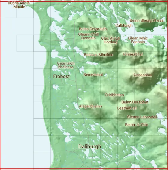
The NF72 10 square kilometre grid intersects with the settlements of Dalabrog / Daliburgh & Loch Baghasdail.
NF72
NF72 is within the post town of Isle Of South Uist, Inverness-shire.
The square is within Na h-Eileanan an Iar council.
The NF72 national grid square measures 10 km by 10 km and has an area of 1,000 kilometres squared.
The technical term for a 10 km map square is a Hectad.
When this 10 km square is divided into a grid 10 by 10 it gives the next size of grid square. This unit is called a Monad and measures 1km square. 100 monads fit in a 10km square.
Out of the monads generated from square NF72, 153 are land and -53 are sea. Sea squares are disregarded on this site as they contain no land features.
|
|
|
|
 |
|
|
|
|
|
|
 |  |  |  |  |  |  |  |  |  |
 |  |  |  |  |  |  |  | ||
 |  |  |  |  |  |  |  |  | |
 |  |  |  |  |  |  |  | ||
 |  |  |  |  |  |  |  | ||
 |  |  |  |  |  |  |  | ||
 |  |  |  |  |  |  |  | ||
 |  |  |  |  |  |  |  | ||
 |  |  |  |  |  |  |  | ||
 |  |  |  |  |  |  |  |
| Corner | Latitude | Longitude | Easting | Northing |
|---|---|---|---|---|
| South West Corner | 57.151781 | -7.472622 | 70000 | 820000 |
| South East Corner | 57.151781 | -7.294800 | 80000 | 820000 |
| North West Corner | 57.248298 | -7.472622 | 70000 | 830000 |
| North East Corner | 57.248298 | -7.294800 | 80000 | 830000 |