Search for Grid Square by Postcode
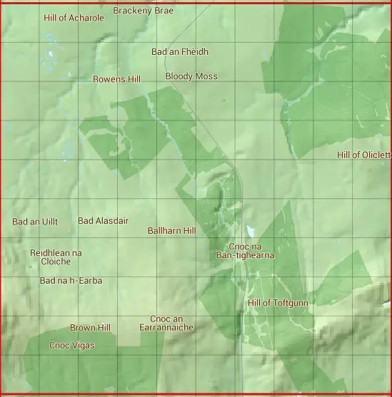
ND24
Based in the Highlands and Islands region of Scotland.
ND24
ND24 is within the post towns of Latheron, Caithness, Lybster, Caithness & Wick, Caithness.
The square is within Highland council.
The ND24 national grid square measures 10 km by 10 km and has an area of 1,000 kilometres squared.
The technical term for a 10 km map square is a Hectad.
When this 10 km square is divided into a grid 10 by 10 it gives the next size of grid square. This unit is called a Monad and measures 1km square. 100 monads fit in a 10km square.
Out of the monads generated from square ND24, 224 are land and -124 are sea. Sea squares are disregarded on this site as they contain no land features.
|
|
|
|
|
|
 |
|
|
|
|
|
 |  |  |  |  |  |  |  |  |  |
 |  |  |  |  |  |  |  |  |  |
 |  |  |  |  |  |  |  |  |  |
 |  |  |  |  |  |  |  |  |  |
 |  |  |  |  |  |  |  |  |  |
 |  |  |  |  |  |  |  |  |  |
 |  |  |  |  |  |  |  |  |  |
 |  |  |  |  |  |  |  |  |  |
 |  |  |  |  |  |  |  |  |  |
 |  |  |  |  |  |  |  |  |  |
| Corner | Latitude | Longitude | Easting | Northing |
|---|---|---|---|---|
| South West Corner | 58.341172 | -3.371655 | 320000 | 940000 |
| South East Corner | 58.341172 | -3.197410 | 330000 | 940000 |
| North West Corner | 58.432676 | -3.371655 | 320000 | 950000 |
| North East Corner | 58.432676 | -3.197410 | 330000 | 950000 |
1 KM Squares within the ND24 10 KM Square
ND2040 ND2041 ND2042 ND2043 ND2044 ND2045 ND2046 ND2047 ND2048 ND2049 ND2140 ND2141 ND2142 ND2143 ND2144 ND2145 ND2146 ND2147 ND2148 ND2149 ND2240 ND2241 ND2242 ND2243 ND2244 ND2245 ND2246 ND2247 ND2248 ND2249 ND2340 ND2341 ND2342
ND2343 ND2344 ND2345 ND2346 ND2347 ND2348 ND2349 ND2440 ND2441 ND2442 ND2443 ND2444 ND2445 ND2446 ND2447 ND2448 ND2449 ND2540 ND2541 ND2542 ND2543 ND2544 ND2545 ND2546 ND2547 ND2548 ND2549 ND2640 ND2641 ND2642 ND2643 ND2644 ND2645