Search for Grid Square by Postcode
HY50
Based in the Highlands and Islands region of Scotland.
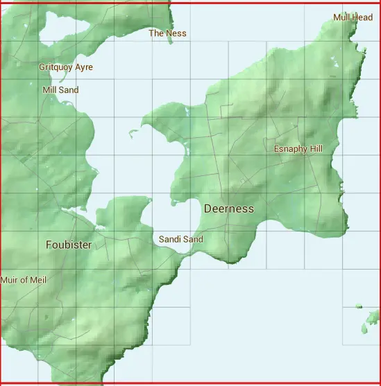
The HY50 10 square kilometre grid intersects with the settlements of Deerness,Tankerness,Toab & Upper Sanday.
HY50
HY50 is within the post town of Orkney.
The square is within Orkney Islands council.
The HY50 national grid square measures 10 km by 10 km and has an area of 1,000 kilometres squared.
The technical term for a 10 km map square is a Hectad.
When this 10 km square is divided into a grid 10 by 10 it gives the next size of grid square. This unit is called a Monad and measures 1km square. 100 monads fit in a 10km square.
Out of the monads generated from square HY50, 166 are land and -66 are sea. Sea squares are disregarded on this site as they contain no land features.
|
|
|
|
|
|
 |
|
|
|
|
 |  |  |  |  |  |  | |||
 |  |  |  |  |  |  |  |  | |
 |  |  |  |  |  |  |  |  |  |
 |  |  |  |  |  |  |  |  |  |
 |  |  |  |  |  |  |  |  |  |
 |  |  |  |  |  |  |  |  |  |
 |  |  |  |  |  |  |  |  |  |
 |  |  |  |  |  | ||||
 |  |  |  |  |  | ||||
 |  |  |  |
| Corner | Latitude | Longitude | Easting | Northing |
|---|---|---|---|---|
| South West Corner | 58.884423 | -2.871367 | 350000 | 1000000 |
| South East Corner | 58.884423 | -2.695647 | 360000 | 1000000 |
| North West Corner | 58.975273 | -2.871367 | 350000 | 1010000 |
| North East Corner | 58.975273 | -2.695647 | 360000 | 1010000 |
1 KM Squares within the HY50 10 KM Square
HY5000 HY5001 HY5002 HY5003 HY5004 HY5005 HY5006 HY5007 HY5008 HY5009 HY5100 HY5101 HY5102 HY5103 HY5104 HY5105 HY5106 HY5107 HY5108 HY5109 HY5200 HY5201 HY5202 HY5203 HY5204 HY5205 HY5206
HY5207 HY5208 HY5209 HY5300 HY5301 HY5302 HY5303 HY5304 HY5305 HY5306 HY5307 HY5309 HY5401 HY5402 HY5403 HY5404 HY5405 HY5406 HY5407 HY5408 HY5409 HY5503 HY5504 HY5505 HY5506 HY5507 HY5508